
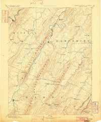
~ Romney WV topo map, 1:125000 scale, 30 X 30 Minute, Historical, 1891, updated 1902
Romney, West Virginia, USGS topographic map dated 1891.
Includes geographic coordinates (latitude and longitude). This topographic map is suitable for hiking, camping, and exploring, or framing it as a wall map.
Printed on-demand using high resolution imagery, on heavy weight and acid free paper, or alternatively on a variety of synthetic materials.
Topos available on paper, Waterproof, Poly, or Tyvek. Usually shipping rolled, unless combined with other folded maps in one order.
- Product Number: USGS-5416154
- Free digital map download (high-resolution, GeoPDF): Romney, West Virginia (file size: 8 MB)
- Map Size: please refer to the dimensions of the GeoPDF map above
- Weight (paper map): ca. 55 grams
- Map Type: POD USGS Topographic Map
- Map Series: HTMC
- Map Verison: Historical
- Cell ID: 66483
- Scan ID: 254013
- Imprint Year: 1902
- Survey Year: 1885
- Datum: Unstated
- Map Projection: Unstated
- Map published by United States Geological Survey
- Map Language: English
- Scanner Resolution: 600 dpi
- Map Cell Name: Romney
- Grid size: 30 X 30 Minute
- Date on map: 1891
- Map Scale: 1:125000
- Geographical region: West Virginia, United States
Neighboring Maps:
All neighboring USGS topo maps are available for sale online at a variety of scales.
Spatial coverage:
Topo map Romney, West Virginia, covers the geographical area associated the following places:
- Wickham - Cunningham - Valley (historical) - Sector - Donaldson - Burlington - Milleson - Doman (historical) - Pancake - Ridgedale - Ridgeville - Dillons Run (historical) - North River Mills - Millbrook - Davis Ford - Hoy - Arkansas - Keyser - Augusta - Blues Beach - Intermont - Raven Rocks - Baker - Wardensville - Millesons Mill - Taylor - Vance - Rock Oak - Reeses Mill - McCauley - McCoole - Creekvale - Barnes Mill - Three Churches - Furnace (historical) - Meadow - Rio - Limestone - Baughman Settlement - Romney - Higginsville - Levels - Noswad (historical) - Slanesville - Bean Settlement - Forge Hill - Inkerman - Loom - Spring Gap (historical) - Frenchburg - Ruckman - Dawson - Russelldale - Needmore - Capon Springs Station (historical) - Wapocomo - McNeill - Capon Lake - Champwood - Markwood - Pleasantdale - Yellow Spring - Fabius (historical) - Johnson - Rada - Sycamore - Springfield - Mechanicsburg - Fort Run - Delray - Glebe (historical) - Ritters - Junction - Headsville - Tannery - Gerstell - Grace - Black Oak - Moorefield - Purgitsville - Points - Old Fields - Shanks - Kirby - Sedan - Mapleton (historical)
- Map Area ID: AREA39.539-79-78.5
- Northwest corner Lat/Long code: USGSNW39.5-79
- Northeast corner Lat/Long code: USGSNE39.5-78.5
- Southwest corner Lat/Long code: USGSSW39-79
- Southeast corner Lat/Long code: USGSSE39-78.5
- Northern map edge Latitude: 39.5
- Southern map edge Latitude: 39
- Western map edge Longitude: -79
- Eastern map edge Longitude: -78.5


