
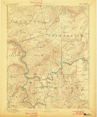
~ Hinton WV topo map, 1:125000 scale, 30 X 30 Minute, Historical, 1892, updated 1901
Hinton, West Virginia, USGS topographic map dated 1892.
Includes geographic coordinates (latitude and longitude). This topographic map is suitable for hiking, camping, and exploring, or framing it as a wall map.
Printed on-demand using high resolution imagery, on heavy weight and acid free paper, or alternatively on a variety of synthetic materials.
Topos available on paper, Waterproof, Poly, or Tyvek. Usually shipping rolled, unless combined with other folded maps in one order.
- Product Number: USGS-5416142
- Free digital map download (high-resolution, GeoPDF): Hinton, West Virginia (file size: 9 MB)
- Map Size: please refer to the dimensions of the GeoPDF map above
- Weight (paper map): ca. 55 grams
- Map Type: POD USGS Topographic Map
- Map Series: HTMC
- Map Verison: Historical
- Cell ID: 65683
- Scan ID: 253970
- Imprint Year: 1901
- Survey Year: 1887
- Datum: Unstated
- Map Projection: Unstated
- Map published by United States Geological Survey
- Map Language: English
- Scanner Resolution: 600 dpi
- Map Cell Name: Hinton
- Grid size: 30 X 30 Minute
- Date on map: 1892
- Map Scale: 1:125000
- Geographical region: West Virginia, United States
Neighboring Maps:
All neighboring USGS topo maps are available for sale online at a variety of scales.
Spatial coverage:
Topo map Hinton, West Virginia, covers the geographical area associated the following places:
- Layland - Salt Sulphur Springs - Smoot - Warford (historical) - Elmhurst - Pickaway - Cornstalk - Johnson Crossroads - Lawton - Crumps Bottom - Snowflake - Abraham - Fairview (historical) - Browning - Crawley - Junta (historical) - Wayside - Marie - Layland Heights - Crag - Palestine - Meadow Bluff - Beelick Knob - Bragg - Elton - Grassy Meadows - Barnettown - Raines Corner - Suck Creek - Pluto - Egypt (historical) - True - Sarton - Lillydale - Wiggins - Clayton - Lawn - Bertha - Barksdale - Forest Hill - Hines - Hughart - Blaker Mills - Shawvers Crossing - Lilly Park - Carew - Hokes Mill - Kessler - Dawson - Brooks - Chestnut Knob - Rock Cliff - Meadow Bridge - Kathryn - Creamery - Willow Bend - Hilldale - Buck - Riffe - Half Way - Ramp - Talcott - Landisburg - Crossroads - Ellison - Wikel - Sandstone - Meadow Creek - Farmdale - Pence Springs - Nimitz - Bellepoint - Pipestem - Clintonville - Tempa - Tina (historical) - Hinton - Indian Mills - Lilly (historical) - Bargers Springs - Dennis - Vale - Fort Spring - Avis - Hemlock - Zenith - Seminole - Pear (historical) - Judson - Jumping Branch - Greenwood (historical) - Lockbridge - Sturgeon Branch (historical) - Blue Sulphur Springs - Pittman - Rockland - Glenray - Union - Sinks Grove - Alta
- Map Area ID: AREA3837.5-81-80.5
- Northwest corner Lat/Long code: USGSNW38-81
- Northeast corner Lat/Long code: USGSNE38-80.5
- Southwest corner Lat/Long code: USGSSW37.5-81
- Southeast corner Lat/Long code: USGSSE37.5-80.5
- Northern map edge Latitude: 38
- Southern map edge Latitude: 37.5
- Western map edge Longitude: -81
- Eastern map edge Longitude: -80.5


