
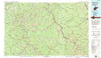
~ Williamson WV topo map, 1:100000 scale, 30 X 60 Minute, Historical, 1982, updated 1983
Williamson, West Virginia, USGS topographic map dated 1982.
Includes geographic coordinates (latitude and longitude). This topographic map is suitable for hiking, camping, and exploring, or framing it as a wall map.
Printed on-demand using high resolution imagery, on heavy weight and acid free paper, or alternatively on a variety of synthetic materials.
Topos available on paper, Waterproof, Poly, or Tyvek. Usually shipping rolled, unless combined with other folded maps in one order.
- Product Number: USGS-5416122
- Free digital map download (high-resolution, GeoPDF): Williamson, West Virginia (file size: 30 MB)
- Map Size: please refer to the dimensions of the GeoPDF map above
- Weight (paper map): ca. 55 grams
- Map Type: POD USGS Topographic Map
- Map Series: HTMC
- Map Verison: Historical
- Cell ID: 68592
- Scan ID: 701707
- Imprint Year: 1983
- Woodland Tint: Yes
- Aerial Photo Year: 1977
- Edit Year: 1982
- Datum: NAD27
- Map Projection: Universal Transverse Mercator
- Map published by United States Geological Survey
- Map Language: English
- Scanner Resolution: 508 dpi
- Map Cell Name: Williamson
- Grid size: 30 X 60 Minute
- Date on map: 1982
- Map Scale: 1:100000
- Geographical region: West Virginia, United States
Neighboring Maps:
All neighboring USGS topo maps are available for sale online at a variety of scales.
Spatial coverage:
Topo map Williamson, West Virginia, covers the geographical area associated the following places:
- Moree - Hedgeview - Brainard - Columbiatown (historical) - City View Addition - Buskirk - Sidney - Davis - Pie - Walnut Hill - Delbarton - Board Tree - Cliff - McClure - Thompson Town - East Kermit - Dwale - Odds - Musick - Beebe - Puritan Mines - Wagoner (historical) - Stepptown - Vulcan - Allen City - Belo - Ulysses - Lando Mines - Baisden - Greyeagle - Zebulon - Beaver Junction - Left Fork of Blackberry (historical) - Dingess - McCarr - Pinsonfork - New Alma Coal Camp (historical) - Georges Creek - Doane - Bays Branch - Warfield - Relief - Lowney - Ajax - Webb - Phico - West Van Lear - Devon - Thacker - Arkansas - Fredville - Chandlerville - Hippo - Lintz Addition - Big Shoal (historical) - Pine Creek - Noris - Marshallville - CC Maynards Settlement (historical) - Cinderella - Nolan - McVeigh - Van Lear - Goody - Tripp - Hardy - Burnwell - Lovely - Breeden - Job - Bias - Lynn - Maher - East Williamson - Blue River - Sulphur Springs - Sunset Court - Inez - Kitchen - Kerz - Boldman - Holden - Scarlet - Wittensville - Miller Creek (historical) - New Thacker (historical) - Hagerhill - Thomas - Colliver - Upper Tug (historical) - Riceville - Stidham - Williamsport - Watergap - Slatter Branch (historical) - Tom Ray (historical) - Tutor Key - Surosa - Phelps - Mouth of Long Fork (historical)
- Map Area ID: AREA3837.5-83-82
- Northwest corner Lat/Long code: USGSNW38-83
- Northeast corner Lat/Long code: USGSNE38-82
- Southwest corner Lat/Long code: USGSSW37.5-83
- Southeast corner Lat/Long code: USGSSE37.5-82
- Northern map edge Latitude: 38
- Southern map edge Latitude: 37.5
- Western map edge Longitude: -83
- Eastern map edge Longitude: -82


