
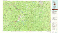
~ Sutton WV topo map, 1:100000 scale, 30 X 60 Minute, Historical, 1981, updated 1982
Sutton, West Virginia, USGS topographic map dated 1981.
Includes geographic coordinates (latitude and longitude). This topographic map is suitable for hiking, camping, and exploring, or framing it as a wall map.
Printed on-demand using high resolution imagery, on heavy weight and acid free paper, or alternatively on a variety of synthetic materials.
Topos available on paper, Waterproof, Poly, or Tyvek. Usually shipping rolled, unless combined with other folded maps in one order.
- Product Number: USGS-5416120
- Free digital map download (high-resolution, GeoPDF): Sutton, West Virginia (file size: 29 MB)
- Map Size: please refer to the dimensions of the GeoPDF map above
- Weight (paper map): ca. 55 grams
- Map Type: POD USGS Topographic Map
- Map Series: HTMC
- Map Verison: Historical
- Cell ID: 68428
- Scan ID: 701706
- Imprint Year: 1982
- Woodland Tint: Yes
- Aerial Photo Year: 1976
- Edit Year: 1981
- Datum: NAD27
- Map Projection: Universal Transverse Mercator
- Map published by United States Geological Survey
- Map Language: English
- Scanner Resolution: 508 dpi
- Map Cell Name: Sutton
- Grid size: 30 X 60 Minute
- Date on map: 1981
- Map Scale: 1:100000
- Geographical region: West Virginia, United States
Neighboring Maps:
All neighboring USGS topo maps are available for sale online at a variety of scales.
Spatial coverage:
Topo map Sutton, West Virginia, covers the geographical area associated the following places:
- Blackburn - Heaters - De Kalb - Valley Head - Brady Gate - Alkires Mills - Harrison - Herold - Erbacon - Hardman - Fairview - Chapman - Alice - Queens - Finegan Ford - Burnsville - Hettie - O'Brion - Daysville - Baldwin - Frame Knob (historical) - Heavner (historical) - Gale - South Buckhannon - Rock Cave - Copley - Stouts Mills - Holly Grove - Flatwoods - Chemical (historical) - Hope (historical) - Huff (historical) - Blue Spring - Glenville - Penbro (historical) - Bakers Run - Palmer - Freeman - Wade - Lucerne - Adolph - Wilsie - Middlebrook - Rocky Ford - Spangler - Caress - Napier - Rosedale - Jumbo - Zion - Walkersville - Gassaway - Craddock - Normantown - Elkwater - Rohrbough - Hemlock - Helvetia - Morris - Withers - Perkins - Letch - Cassity - Orr - Gem - Hodam - Little Birch - Vegan - Evergreen - Aspinall - Revore - Florence (historical) - Vernon - Diana - Frenchton - Bablin - Ellamore - Lee Bell - Donlan - Adrian - Flower - Alton - Gip - Truebada - Centralia - Crawford - Georgetown - Dora - Duck - Vandalia - Holstead (historical) - Fishers Crossing - Lockney - Suncrest - Ivy - Arnett - Wymer - Cutlips - Emmart - Skelt
- Map Area ID: AREA3938.5-81-80
- Northwest corner Lat/Long code: USGSNW39-81
- Northeast corner Lat/Long code: USGSNE39-80
- Southwest corner Lat/Long code: USGSSW38.5-81
- Southeast corner Lat/Long code: USGSSE38.5-80
- Northern map edge Latitude: 39
- Southern map edge Latitude: 38.5
- Western map edge Longitude: -81
- Eastern map edge Longitude: -80


