
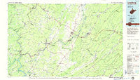
~ Lewisburg WV topo map, 1:100000 scale, 30 X 60 Minute, Historical, 1984, updated 1985
Lewisburg, West Virginia, USGS topographic map dated 1984.
Includes geographic coordinates (latitude and longitude). This topographic map is suitable for hiking, camping, and exploring, or framing it as a wall map.
Printed on-demand using high resolution imagery, on heavy weight and acid free paper, or alternatively on a variety of synthetic materials.
Topos available on paper, Waterproof, Poly, or Tyvek. Usually shipping rolled, unless combined with other folded maps in one order.
- Product Number: USGS-5416106
- Free digital map download (high-resolution, GeoPDF): Lewisburg, West Virginia (file size: 20 MB)
- Map Size: please refer to the dimensions of the GeoPDF map above
- Weight (paper map): ca. 55 grams
- Map Type: POD USGS Topographic Map
- Map Series: HTMC
- Map Verison: Historical
- Cell ID: 67839
- Scan ID: 701700
- Imprint Year: 1985
- Woodland Tint: Yes
- Aerial Photo Year: 1976
- Edit Year: 1984
- Datum: NAD27
- Map Projection: Universal Transverse Mercator
- Map published by United States Geological Survey
- Map Language: English
- Scanner Resolution: 508 dpi
- Map Cell Name: Lewisburg
- Grid size: 30 X 60 Minute
- Date on map: 1984
- Map Scale: 1:100000
- Geographical region: West Virginia, United States
Neighboring Maps:
All neighboring USGS topo maps are available for sale online at a variety of scales.
Spatial coverage:
Topo map Lewisburg, West Virginia, covers the geographical area associated the following places:
- Rainelle - Dennis - Laurel Creek - Seminole - Valley Heights - Secondcreek - Bellepoint - Tuckahoe - Talcott - Paint Bank - Rockland - Glenray - Hollywood - Vago - Alderson - Nickells Mill - Meadow Bluff - Kathryn - Pittman - Callaghan - Fair Oaks Trailer Park - Blaker Mills - Neola - Palestine - Sandstone - McRoss - Piercys Mill - Brink (historical) - Ballengee - Blue Bend - Pluto - Alvon - Brooklin - Barbours Creek - Alleghany - Judson - Patton - Dogwood Heights - Dawson - Fort Spring - Beurytown - Lillydale - Greenwood (historical) - Williamsburg - Charlton - Teaberry - Clayton - Crossroads - Riffe - Hemlock - Stonewall - Bertha - Danese - New Castle - Anthony - Marie - Forest Hill - Bowes - Salt Sulphur Springs - Monitor - Shawver - Barnettown - Willow Bend - Johnson Crossroads - Cedar Knoll Trailer Park - Junta (historical) - Avis - Caldwell - Lawn - Underwood Estates - Crows - New Richmond (historical) - Abraham - Santifee (historical) - Hematite - Centennial - Chestnut Knob - Kessler - Mountain View Estates - Sims - Hillsdale - Griffith Creek - Hix - Maxwelton - Nimitz - Shryock - Kieffer - North Caldwell - Cornstalk - Maplewood - Clifdale - Creamery - Rupert - Blue Sulphur Springs - Tempa - Brooks - Jumping Branch - Warford (historical) - Lilly (historical) - Alta
- Map Area ID: AREA3837.5-81-80
- Northwest corner Lat/Long code: USGSNW38-81
- Northeast corner Lat/Long code: USGSNE38-80
- Southwest corner Lat/Long code: USGSSW37.5-81
- Southeast corner Lat/Long code: USGSSE37.5-80
- Northern map edge Latitude: 38
- Southern map edge Latitude: 37.5
- Western map edge Longitude: -81
- Eastern map edge Longitude: -80


