
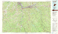
~ Huntington WV topo map, 1:100000 scale, 30 X 60 Minute, Historical, 1982, updated 1983
Huntington, West Virginia, USGS topographic map dated 1982.
Includes geographic coordinates (latitude and longitude). This topographic map is suitable for hiking, camping, and exploring, or framing it as a wall map.
Printed on-demand using high resolution imagery, on heavy weight and acid free paper, or alternatively on a variety of synthetic materials.
Topos available on paper, Waterproof, Poly, or Tyvek. Usually shipping rolled, unless combined with other folded maps in one order.
- Product Number: USGS-5416102
- Free digital map download (high-resolution, GeoPDF): Huntington, West Virginia (file size: 31 MB)
- Map Size: please refer to the dimensions of the GeoPDF map above
- Weight (paper map): ca. 55 grams
- Map Type: POD USGS Topographic Map
- Map Series: HTMC
- Map Verison: Historical
- Cell ID: 67692
- Scan ID: 701698
- Imprint Year: 1983
- Woodland Tint: Yes
- Aerial Photo Year: 1975
- Edit Year: 1982
- Datum: NAD27
- Map Projection: Universal Transverse Mercator
- Map published by United States Geological Survey
- Map Language: English
- Scanner Resolution: 508 dpi
- Map Cell Name: Huntington
- Grid size: 30 X 60 Minute
- Date on map: 1982
- Map Scale: 1:100000
- Geographical region: West Virginia, United States
Neighboring Maps:
All neighboring USGS topo maps are available for sale online at a variety of scales.
Spatial coverage:
Topo map Huntington, West Virginia, covers the geographical area associated the following places:
- Mesa Manor - Leon - Beverly Hills - Palermo - Bethesda - Nestlow - West Hamlin - Princess - Hubbardstown - Chadwick Creek (historical) - Owens Crossing - Gaylersville - Centerville - Walnut Park - Enslow Park Place - Timberlake - Fairview Hill - Lick Creek (historical) - Redwing - Miller Estates - East Lynn - Normal - Providence (historical) - South Point - Lock - Brookdale - Wayne - Garden Farms - Kinder (historical) - Proctorville - Harveytown - Evergreen - Greenwood (historical) - Sidney - Torchlight - Summit - Inez - Price - Edgemont - Pactolus - Rolling Hills - Durbin-Burnaugh (historical) - Johnson (historical) - Sybene - Hurricane - Millseat - Sunrise - Lattin (historical) - Green Valley (historical) - Bradyville - Jenks - Corryville - Glenroy - Booton - Skaggs - Martha - Howells Mill - Westwood - Williams Creek - Brownstown (historical) - Prichard - Smoky Valley (historical) - Harts - Leet - Crockett - Spring Valley - Campbell Park - Nye - Louisa - Walbridge - Naples - Winding Stair - Ceredo - Sweetland - Chapman - Ellen - Allen (historical) - Mouth of Bear (historical) - Mott - Beetle - Fairview - Dunlow - Cox Landing - Wilson - Stamford Park - Riverview - Catlettsburg - Big Sandy Junction - Culloden - Ardel - Beverly Hills - Gallup - Bernie (historical) - Big Creek - Sheridan - Lakeland - Home Park - Montreal (historical) - Indian Meadows - Antioch (historical)
- Map Area ID: AREA38.538-83-82
- Northwest corner Lat/Long code: USGSNW38.5-83
- Northeast corner Lat/Long code: USGSNE38.5-82
- Southwest corner Lat/Long code: USGSSW38-83
- Southeast corner Lat/Long code: USGSSE38-82
- Northern map edge Latitude: 38.5
- Southern map edge Latitude: 38
- Western map edge Longitude: -83
- Eastern map edge Longitude: -82


