
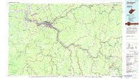
~ Charleston WV topo map, 1:100000 scale, 30 X 60 Minute, Historical, 1984, updated 1984
Charleston, West Virginia, USGS topographic map dated 1984.
Includes geographic coordinates (latitude and longitude). This topographic map is suitable for hiking, camping, and exploring, or framing it as a wall map.
Printed on-demand using high resolution imagery, on heavy weight and acid free paper, or alternatively on a variety of synthetic materials.
Topos available on paper, Waterproof, Poly, or Tyvek. Usually shipping rolled, unless combined with other folded maps in one order.
- Product Number: USGS-5416096
- Free digital map download (high-resolution, GeoPDF): Charleston, West Virginia (file size: 22 MB)
- Map Size: please refer to the dimensions of the GeoPDF map above
- Weight (paper map): ca. 55 grams
- Map Type: POD USGS Topographic Map
- Map Series: HTMC
- Map Verison: Historical
- Cell ID: 67271
- Scan ID: 701694
- Imprint Year: 1984
- Woodland Tint: Yes
- Aerial Photo Year: 1977
- Edit Year: 1984
- Datum: NAD27
- Map Projection: Universal Transverse Mercator
- Map published by United States Geological Survey
- Map Language: English
- Scanner Resolution: 508 dpi
- Map Cell Name: Charleston
- Grid size: 30 X 60 Minute
- Date on map: 1984
- Map Scale: 1:100000
- Geographical region: West Virginia, United States
Neighboring Maps:
All neighboring USGS topo maps are available for sale online at a variety of scales.
Spatial coverage:
Topo map Charleston, West Virginia, covers the geographical area associated the following places:
- Winsor Court - Livingston - Burnwell - South Park - Witcher - Cherry Grove - Fort Hill - Carver (historical) - Ballard (historical) - Gatewood - Shrewsbury - Country Villas - Quarrier - Hillsdale - Leander - Wriston - Robson - Calvert (historical) - Alum Creek - Powellton - Jarrett - Joplin - Copenhaver (historical) - KM Junction - Middle Fork - Coco - Aarons - Bradley - Miami - Hansford - Virginia Heights - South Fayette - Lockwood - Kelly Hill - Harewood - MacDougal - Alloy - Rock Creek - Lincoln (historical) - Dorfee - Clay Junction - Nelson - Hamilton (historical) - Dundon - The Ridge Estates - Victor - Crosby - Williams Mountain - Dickinson - Ortin Heights - Avoca - Dungriff - Baker Park - Mount Carbon - Sun Valley Estates - Airport Village - Shelton - Altman - Old Gauley - Marlaina Addition - South Caperton - Quinland - Wyndal - South Madison - Coalfield - Easly - Turtletown - Fairway Gardens - Deep Water - Rosina (historical) - Glass Addition - Maxine - Annfred - Hidden Valley Estates - Beards Fork - Colonial Gardens - Woods and Irons - North Charleston - Hugheston - Gallagher - Caperton - Peytona - Hollygrove - Longacre - Fairview - Johns - Donwood - Hollyhurst - Danville - Oak Ridge - Sharon - Woods and Irons South - Springdale Estates - Olcott - Riverlake - Blount - Red Warrior - Lincoln Park - Lansing - Madison
- Map Area ID: AREA38.538-82-81
- Northwest corner Lat/Long code: USGSNW38.5-82
- Northeast corner Lat/Long code: USGSNE38.5-81
- Southwest corner Lat/Long code: USGSSW38-82
- Southeast corner Lat/Long code: USGSSE38-81
- Northern map edge Latitude: 38.5
- Southern map edge Latitude: 38
- Western map edge Longitude: -82
- Eastern map edge Longitude: -81


