
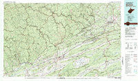
~ Bluefield WV topo map, 1:100000 scale, 30 X 60 Minute, Historical, 1981, updated 1981
Bluefield, West Virginia, USGS topographic map dated 1981.
Includes geographic coordinates (latitude and longitude). This topographic map is suitable for hiking, camping, and exploring, or framing it as a wall map.
Printed on-demand using high resolution imagery, on heavy weight and acid free paper, or alternatively on a variety of synthetic materials.
Topos available on paper, Waterproof, Poly, or Tyvek. Usually shipping rolled, unless combined with other folded maps in one order.
- Product Number: USGS-5416090
- Free digital map download (high-resolution, GeoPDF): Bluefield, West Virginia (file size: 34 MB)
- Map Size: please refer to the dimensions of the GeoPDF map above
- Weight (paper map): ca. 55 grams
- Map Type: POD USGS Topographic Map
- Map Series: HTMC
- Map Verison: Historical
- Cell ID: 72141
- Scan ID: 188765
- Imprint Year: 1981
- Woodland Tint: Yes
- Aerial Photo Year: 1977
- Edit Year: 1981
- Datum: NAD27
- Map Projection: Universal Transverse Mercator
- Map published by United States Geological Survey
- Map Language: English
- Scanner Resolution: 600 dpi
- Map Cell Name: Bluefield
- Grid size: 30 X 60 Minute
- Date on map: 1981
- Map Scale: 1:100000
- Geographical region: West Virginia, United States
Neighboring Maps:
All neighboring USGS topo maps are available for sale online at a variety of scales.
Spatial coverage:
Topo map Bluefield, West Virginia, covers the geographical area associated the following places:
- Elbert - Crusher (historical) - Clell - Flipping - Flatrock - Grapefield - Burkes Garden - Capels - Sayersville - Wolford - Roth - Rolfe - Pisgah - Apple Grove - Weyanoke - Eckman - Shortt Gap - Vivian - Boissevain - Maiden Spring - Piedmont - Micajah - Clark (historical) - Mohegan - Wolfe - Dunford Village - Speedway - Maybeury - Adria - Kimberling - Coaldan - Excelsior - Brewsterdale - Big Four - Gap Store - Sandy Huff - Pinoak - Hale Creek - Monson - Gilliam - Abbs Valley - Littlesburg - Alpheus - Melrose - West Graham - Wittens Mills - Cove Creek - Shack Mills - Bastian - Bernietown - Putnam - Criggers - Princeton - Wilmore - Marytown - Edison - Lamberts Store - Pounding Mill - Ruth (historical) - Hickory Junction - Iaeger - Abbs Valley (historical) - Suiter - Bevers Store (historical) - Kimball - Seaboard - Wilcoe - Avondale - Horn - Youngs (historical) - Filbert - Hiawatha - Yards - Ada - Hull - Peapatch - Pageton - Tabors - Squire - Steeleburg - Big Sandy - Jed - Covel - Gardner - Joe Neets - Byron - Coalwood - Wittens Fort - Big Vein - Wardell - Landgraff - Carnot - Duhring - Gary - Wenonah - Cedar Bluff - Round Bottom - Blackey - Havaco - Horsepen
- Map Area ID: AREA37.537-82-81
- Northwest corner Lat/Long code: USGSNW37.5-82
- Northeast corner Lat/Long code: USGSNE37.5-81
- Southwest corner Lat/Long code: USGSSW37-82
- Southeast corner Lat/Long code: USGSSE37-81
- Northern map edge Latitude: 37.5
- Southern map edge Latitude: 37
- Western map edge Longitude: -82
- Eastern map edge Longitude: -81


