
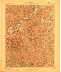
~ Saint Marys WV topo map, 1:62500 scale, 15 X 15 Minute, Historical, 1906
Saint Marys, West Virginia, USGS topographic map dated 1906.
Includes geographic coordinates (latitude and longitude). This topographic map is suitable for hiking, camping, and exploring, or framing it as a wall map.
Printed on-demand using high resolution imagery, on heavy weight and acid free paper, or alternatively on a variety of synthetic materials.
Topos available on paper, Waterproof, Poly, or Tyvek. Usually shipping rolled, unless combined with other folded maps in one order.
- Product Number: USGS-5415880
- Free digital map download (high-resolution, GeoPDF): Saint Marys, West Virginia (file size: 9 MB)
- Map Size: please refer to the dimensions of the GeoPDF map above
- Weight (paper map): ca. 55 grams
- Map Type: POD USGS Topographic Map
- Map Series: HTMC
- Map Verison: Historical
- Cell ID: 61956
- Scan ID: 701421
- Woodland Tint: Yes
- Survey Year: 1904
- Datum: Unstated
- Map Projection: Unstated
- Map published by United States Geological Survey
- Map Language: English
- Scanner Resolution: 508 dpi
- Map Cell Name: Saint Marys
- Grid size: 15 X 15 Minute
- Date on map: 1906
- Map Scale: 1:62500
- Geographical region: West Virginia, United States
Neighboring Maps:
All neighboring USGS topo maps are available for sale online at a variety of scales.
Spatial coverage:
Topo map Saint Marys, West Virginia, covers the geographical area associated the following places:
- Algeria (historical) - Wasp - Wade - Poynette - Pine Grove - Glendale - Federal (historical) - Crisp (historical) - Spring Run - Newport - Finch - Fern - Archers Fork - Ellenboro - Everett - Point Lookout - Pleasants - Vaucluse - Arvilla - Long Reach - Green Run - Twiggs - Pike - DeLong - Maxwell - Wiley - Deucher - Union Mills - Beavertown - Hebron - Lone Valley - Raven Rock - Admiral (historical) - Murphy - Beech Grove - Shiloh - League - Highland - Meadville - Sugar Valley - Bens Run - Lytton (historical) - Schultz - Lamberton - Bevan - Cloverdale - Adlai - Calcutta - Briggs - Saint Marys - Leith - Grape Island - Falls Mills
- Map Area ID: AREA39.539.25-81.25-81
- Northwest corner Lat/Long code: USGSNW39.5-81.25
- Northeast corner Lat/Long code: USGSNE39.5-81
- Southwest corner Lat/Long code: USGSSW39.25-81.25
- Southeast corner Lat/Long code: USGSSE39.25-81
- Northern map edge Latitude: 39.5
- Southern map edge Latitude: 39.25
- Western map edge Longitude: -81.25
- Eastern map edge Longitude: -81


