
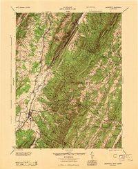
~ Moorefield WV topo map, 1:62500 scale, 15 X 15 Minute, Historical, 1945
Moorefield, West Virginia, USGS topographic map dated 1945.
Includes geographic coordinates (latitude and longitude). This topographic map is suitable for hiking, camping, and exploring, or framing it as a wall map.
Printed on-demand using high resolution imagery, on heavy weight and acid free paper, or alternatively on a variety of synthetic materials.
Topos available on paper, Waterproof, Poly, or Tyvek. Usually shipping rolled, unless combined with other folded maps in one order.
- Product Number: USGS-5415632
- Free digital map download (high-resolution, GeoPDF): Moorefield, West Virginia (file size: 11 MB)
- Map Size: please refer to the dimensions of the GeoPDF map above
- Weight (paper map): ca. 55 grams
- Map Type: POD USGS Topographic Map
- Map Series: HTMC
- Map Verison: Historical
- Cell ID: 57850
- Scan ID: 253713
- Woodland Tint: Yes
- Aerial Photo Year: 1943
- Datum: NAD
- Map Projection: Polyconic
- Map published by United States Army Corps of Engineers
- Map published by United States Department of War
- Map Language: English
- Scanner Resolution: 600 dpi
- Map Cell Name: Moorefield
- Grid size: 15 X 15 Minute
- Date on map: 1945
- Map Scale: 1:62500
- Geographical region: West Virginia, United States
Neighboring Maps:
All neighboring USGS topo maps are available for sale online at a variety of scales.
Spatial coverage:
Topo map Moorefield, West Virginia, covers the geographical area associated the following places:
- Sycamore - Tannery - Taylor - Bean Settlement - Fabius (historical) - Meadow - Inkerman - Glebe (historical) - Wickham - McNeill - Doman (historical) - Old Fields - Cunningham - Mapleton (historical) - Moorefield - Fort Run - Sector - Purgitsville - Needmore
- Map Area ID: AREA39.2539-79-78.75
- Northwest corner Lat/Long code: USGSNW39.25-79
- Northeast corner Lat/Long code: USGSNE39.25-78.75
- Southwest corner Lat/Long code: USGSSW39-79
- Southeast corner Lat/Long code: USGSSE39-78.75
- Northern map edge Latitude: 39.25
- Southern map edge Latitude: 39
- Western map edge Longitude: -79
- Eastern map edge Longitude: -78.75


