
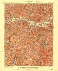
~ Milton WV topo map, 1:62500 scale, 15 X 15 Minute, Historical, 1935
Milton, West Virginia, USGS topographic map dated 1935.
Includes geographic coordinates (latitude and longitude). This topographic map is suitable for hiking, camping, and exploring, or framing it as a wall map.
Printed on-demand using high resolution imagery, on heavy weight and acid free paper, or alternatively on a variety of synthetic materials.
Topos available on paper, Waterproof, Poly, or Tyvek. Usually shipping rolled, unless combined with other folded maps in one order.
- Product Number: USGS-5415600
- Free digital map download (high-resolution, GeoPDF): Milton, West Virginia (file size: 10 MB)
- Map Size: please refer to the dimensions of the GeoPDF map above
- Weight (paper map): ca. 55 grams
- Map Type: POD USGS Topographic Map
- Map Series: HTMC
- Map Verison: Historical
- Cell ID: 57681
- Scan ID: 701057
- Edit Year: 1901
- Datum: NAD
- Map Projection: Polyconic
- Map published by United States Geological Survey
- Map Language: English
- Scanner Resolution: 508 dpi
- Map Cell Name: Milton
- Grid size: 15 X 15 Minute
- Date on map: 1935
- Map Scale: 1:62500
- Geographical region: West Virginia, United States
Neighboring Maps:
All neighboring USGS topo maps are available for sale online at a variety of scales.
Spatial coverage:
Topo map Milton, West Virginia, covers the geographical area associated the following places:
- Westview Estates - Wheeler Ridge - Fudges Creek - Nye - Imperial Estates - Rolling Hills - Indian Meadows - Inez - Howells Mill - West Hamlin - Bowles - Malcolm Springs Heights - Yates Crossing - Eggleton - Sweetland - Portersville - New Hamlin - Thompson Acres - Prairietown - Salt Rock - Hurricane - Knollview Estates - Thompson Heights - Hamlin - Hurricane Bridge (historical) - Ona - Lake Washington - Blue Sulphur - Milton - Mesa Manor - Culloden
- Map Area ID: AREA38.538.25-82.25-82
- Northwest corner Lat/Long code: USGSNW38.5-82.25
- Northeast corner Lat/Long code: USGSNE38.5-82
- Southwest corner Lat/Long code: USGSSW38.25-82.25
- Southeast corner Lat/Long code: USGSSE38.25-82
- Northern map edge Latitude: 38.5
- Southern map edge Latitude: 38.25
- Western map edge Longitude: -82.25
- Eastern map edge Longitude: -82


