
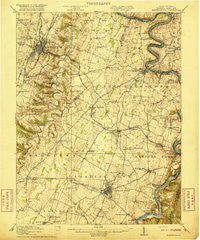
~ Martinsburg WV topo map, 1:62500 scale, 15 X 15 Minute, Historical, 1916
Martinsburg, West Virginia, USGS topographic map dated 1916.
Includes geographic coordinates (latitude and longitude). This topographic map is suitable for hiking, camping, and exploring, or framing it as a wall map.
Printed on-demand using high resolution imagery, on heavy weight and acid free paper, or alternatively on a variety of synthetic materials.
Topos available on paper, Waterproof, Poly, or Tyvek. Usually shipping rolled, unless combined with other folded maps in one order.
- Product Number: USGS-5415552
- Free digital map download (high-resolution, GeoPDF): Martinsburg, West Virginia (file size: 9 MB)
- Map Size: please refer to the dimensions of the GeoPDF map above
- Weight (paper map): ca. 55 grams
- Map Type: POD USGS Topographic Map
- Map Series: HTMC
- Map Verison: Historical
- Cell ID: 57239
- Scan ID: 253673
- Woodland Tint: Yes
- Survey Year: 1914
- Datum: Unstated
- Map Projection: Unstated
- Map published by United States Geological Survey
- Map Language: English
- Scanner Resolution: 600 dpi
- Map Cell Name: Martinsburg
- Grid size: 15 X 15 Minute
- Date on map: 1916
- Map Scale: 1:62500
- Geographical region: West Virginia, United States
Neighboring Maps:
All neighboring USGS topo maps are available for sale online at a variety of scales.
Spatial coverage:
Topo map Martinsburg, West Virginia, covers the geographical area associated the following places:
- Blair - Uvilla - Foltz (historical) - Brooke Haven - Grubbs Corner - Duffields - Martinsburg - Shenandoah Junction - Engle - Bolivar - Wynkoop Spring - Bloomery - Ranson - Blairton - Mechlenberg Heights - Johnsontown - Potomac Crest - Browns Corner - Millville - Silver Grove - Files Crossroad - Blue Ridge Acres - Scrabble - Clips Mill - Halltown - Morgan Grove - Skeetersville - Baker Heights - Charles Town - Rosemont - Adam Stephen Homes - Boydville - Snyders Landing - Berkeley Place - Confederate Hills - Taylors Landing - Heatherfield - Aldridge - Shepherdstown - Vanville - Belvedere Heights - Harmony (historical) - Kearneysville - Potomac Valley Farms - Douglas Grove - Walpers Cross-Roads - Mount Pleasant - Mount Pleasant - Irish Hill - Egypt - Greensburg - Bakerton - Rose Hill - Swan Pond - Reedson - Harewood - Pikeside - Van Clevesville - Jefferson Village - Middleway - Mondell - Leetown - Mercersville - Winebrenners Crossroad - Keyes Ferry Acres - Moler Crossroads - Keys Gap - Bardane - Mechanicstown
- Map Area ID: AREA39.539.25-78-77.75
- Northwest corner Lat/Long code: USGSNW39.5-78
- Northeast corner Lat/Long code: USGSNE39.5-77.75
- Southwest corner Lat/Long code: USGSSW39.25-78
- Southeast corner Lat/Long code: USGSSE39.25-77.75
- Northern map edge Latitude: 39.5
- Southern map edge Latitude: 39.25
- Western map edge Longitude: -78
- Eastern map edge Longitude: -77.75


