
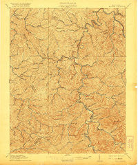
~ Madison WV topo map, 1:62500 scale, 15 X 15 Minute, Historical, 1911, updated 1921
Madison, West Virginia, USGS topographic map dated 1911.
Includes geographic coordinates (latitude and longitude). This topographic map is suitable for hiking, camping, and exploring, or framing it as a wall map.
Printed on-demand using high resolution imagery, on heavy weight and acid free paper, or alternatively on a variety of synthetic materials.
Topos available on paper, Waterproof, Poly, or Tyvek. Usually shipping rolled, unless combined with other folded maps in one order.
- Product Number: USGS-5415512
- Free digital map download (high-resolution, GeoPDF): Madison, West Virginia (file size: 13 MB)
- Map Size: please refer to the dimensions of the GeoPDF map above
- Weight (paper map): ca. 55 grams
- Map Type: POD USGS Topographic Map
- Map Series: HTMC
- Map Verison: Historical
- Cell ID: 57034
- Scan ID: 253651
- Imprint Year: 1921
- Survey Year: 1909
- Datum: Unstated
- Map Projection: Unstated
- Map published by United States Geological Survey
- Map Language: English
- Scanner Resolution: 600 dpi
- Map Cell Name: Madison
- Grid size: 15 X 15 Minute
- Date on map: 1911
- Map Scale: 1:62500
- Geographical region: West Virginia, United States
Neighboring Maps:
All neighboring USGS topo maps are available for sale online at a variety of scales.
Spatial coverage:
Topo map Madison, West Virginia, covers the geographical area associated the following places:
- Alkol - South Madison - Powell Creek - Brounland - Breece - Estep - Altman - Griffithsville - Hopkins - Yawkey - Fork Junction - Horse Creek Junction - Danville - Quinland - Lory - Ridgeview - Foch - Layville - Foster - Dollie - Adams - Emmons - Morrisvale - Summit - Low Gap - East (historical) - Price Hill - Snowden - Dodson Junction - Julian - Brush Creek - Irene - Washington Heights - Sumerco - Van Camp - Rock Creek - Bulger - Harless - Uneeda - Hollyhurst - Madison - Cameo - Sod - Turtletown - Woodville - McCorkle - Haddleton - Turtle Creek
- Map Area ID: AREA38.2538-82-81.75
- Northwest corner Lat/Long code: USGSNW38.25-82
- Northeast corner Lat/Long code: USGSNE38.25-81.75
- Southwest corner Lat/Long code: USGSSW38-82
- Southeast corner Lat/Long code: USGSSE38-81.75
- Northern map edge Latitude: 38.25
- Southern map edge Latitude: 38
- Western map edge Longitude: -82
- Eastern map edge Longitude: -81.75


