
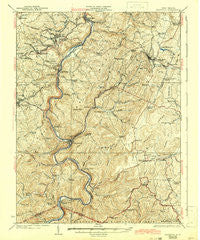
~ Kingwood WV topo map, 1:62500 scale, 15 X 15 Minute, Historical, 1925, updated 1942
Kingwood, West Virginia, USGS topographic map dated 1925.
Includes geographic coordinates (latitude and longitude). This topographic map is suitable for hiking, camping, and exploring, or framing it as a wall map.
Printed on-demand using high resolution imagery, on heavy weight and acid free paper, or alternatively on a variety of synthetic materials.
Topos available on paper, Waterproof, Poly, or Tyvek. Usually shipping rolled, unless combined with other folded maps in one order.
- Product Number: USGS-5415470
- Free digital map download (high-resolution, GeoPDF): Kingwood, West Virginia (file size: 11 MB)
- Map Size: please refer to the dimensions of the GeoPDF map above
- Weight (paper map): ca. 55 grams
- Map Type: POD USGS Topographic Map
- Map Series: HTMC
- Map Verison: Historical
- Cell ID: 56215
- Scan ID: 253625
- Imprint Year: 1942
- Survey Year: 1905
- Datum: NAD
- Map Projection: Polyconic
- Map published by United States Geological Survey
- Map Language: English
- Scanner Resolution: 600 dpi
- Map Cell Name: Kingwood
- Grid size: 15 X 15 Minute
- Date on map: 1925
- Map Scale: 1:62500
- Geographical region: West Virginia, United States
Neighboring Maps:
All neighboring USGS topo maps are available for sale online at a variety of scales.
Spatial coverage:
Topo map Kingwood, West Virginia, covers the geographical area associated the following places:
- Preston - Trowbridge (historical) - Albright - Whetsell (historical) - Borgman - Snider - Rodemer - Anderson - Caddell - Sell - Brookside - Mount Olivet - Manown - Irona - Eglon - Zevely - Terra Alta - Carmel - Salt Lick - Freeport - Amblersburg - Atlantic (historical) - Blaser - Etam - White Oak Springs - Hardesty - Mountain View - Breedlove (historical) - Camp Ground - Buckhorn (historical) - Kingwood - Dayton - Amboy - Erwin - Manheim - Horse Shoe Run - Macomber - Alpine Lake - Heathers Run - Tunnelton - Saint Joe - Aurora - Hopemont - Rowlesburg
- Map Area ID: AREA39.539.25-79.75-79.5
- Northwest corner Lat/Long code: USGSNW39.5-79.75
- Northeast corner Lat/Long code: USGSNE39.5-79.5
- Southwest corner Lat/Long code: USGSSW39.25-79.75
- Southeast corner Lat/Long code: USGSSE39.25-79.5
- Northern map edge Latitude: 39.5
- Southern map edge Latitude: 39.25
- Western map edge Longitude: -79.75
- Eastern map edge Longitude: -79.5


