
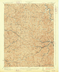
~ Holden WV topo map, 1:62500 scale, 15 X 15 Minute, Historical, 1928
Holden, West Virginia, USGS topographic map dated 1928.
Includes geographic coordinates (latitude and longitude). This topographic map is suitable for hiking, camping, and exploring, or framing it as a wall map.
Printed on-demand using high resolution imagery, on heavy weight and acid free paper, or alternatively on a variety of synthetic materials.
Topos available on paper, Waterproof, Poly, or Tyvek. Usually shipping rolled, unless combined with other folded maps in one order.
- Product Number: USGS-5415428
- Free digital map download (high-resolution, GeoPDF): Holden, West Virginia (file size: 13 MB)
- Map Size: please refer to the dimensions of the GeoPDF map above
- Weight (paper map): ca. 55 grams
- Map Type: POD USGS Topographic Map
- Map Series: HTMC
- Map Verison: Historical
- Cell ID: 55378
- Scan ID: 253601
- Survey Year: 1910
- Datum: NAD
- Map Projection: Polyconic
- Map published by United States Geological Survey
- Map Language: English
- Scanner Resolution: 600 dpi
- Map Cell Name: Holden
- Grid size: 15 X 15 Minute
- Date on map: 1928
- Map Scale: 1:62500
- Geographical region: West Virginia, United States
Neighboring Maps:
All neighboring USGS topo maps are available for sale online at a variety of scales.
Spatial coverage:
Topo map Holden, West Virginia, covers the geographical area associated the following places:
- Phico - Scarlet - Diamond - Sulphur Springs - Trace Junction - Holden - Stone Branch - Beebe - Baisden - Whitman - Halcyon - Thompson Town - Trace - Belo - Stollings (historical) - Ridgeview - Kitchen - Whites Addition - Pine Creek - Bradshaw - Whirlwind - Verdunville - Logan Heights - Parsley - Davis - City View Addition - Monitor - Upper Whitman - Sunset Court - Hedgeview - Walnut Hill - Mount Gay - Myrtle - Kirk - Godby Heights - Sycamore - Whitman Junction - Shegon - Yantus (historical) - Lintz Addition - Troy Town - Shively - Frogtown - Dingess - Chapmanville - McCloud - Cora - Black Bottom - Shamrock
- Map Area ID: AREA3837.75-82.25-82
- Northwest corner Lat/Long code: USGSNW38-82.25
- Northeast corner Lat/Long code: USGSNE38-82
- Southwest corner Lat/Long code: USGSSW37.75-82.25
- Southeast corner Lat/Long code: USGSSE37.75-82
- Northern map edge Latitude: 38
- Southern map edge Latitude: 37.75
- Western map edge Longitude: -82.25
- Eastern map edge Longitude: -82


