
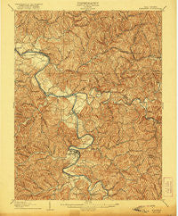
~ Elizabeth WV topo map, 1:62500 scale, 15 X 15 Minute, Historical, 1906, updated 1921
Elizabeth, West Virginia, USGS topographic map dated 1906.
Includes geographic coordinates (latitude and longitude). This topographic map is suitable for hiking, camping, and exploring, or framing it as a wall map.
Printed on-demand using high resolution imagery, on heavy weight and acid free paper, or alternatively on a variety of synthetic materials.
Topos available on paper, Waterproof, Poly, or Tyvek. Usually shipping rolled, unless combined with other folded maps in one order.
- Product Number: USGS-5415216
- Free digital map download (high-resolution, GeoPDF): Elizabeth, West Virginia (file size: 13 MB)
- Map Size: please refer to the dimensions of the GeoPDF map above
- Weight (paper map): ca. 55 grams
- Map Type: POD USGS Topographic Map
- Map Series: HTMC
- Map Verison: Historical
- Cell ID: 53799
- Scan ID: 253487
- Imprint Year: 1921
- Survey Year: 1904
- Datum: Unstated
- Map Projection: Unstated
- Map published by United States Geological Survey
- Map Language: English
- Scanner Resolution: 600 dpi
- Map Cell Name: Elizabeth
- Grid size: 15 X 15 Minute
- Date on map: 1906
- Map Scale: 1:62500
- Geographical region: West Virginia, United States
Neighboring Maps:
All neighboring USGS topo maps are available for sale online at a variety of scales.
Spatial coverage:
Topo map Elizabeth, West Virginia, covers the geographical area associated the following places:
- Weekleys (historical) - Chesterville - Rover - Dallison - Enterprise - Freeport - Cisco - Hughs Subdivision - Palestine - Greencastle - Leachtown - Girta - Rusk - Laurel Junction (historical) - Slate - Oil Spring - Red Hill - Hanna - Cherry - Kanawha - Cool Springs - Elizabeth - Newark - Petroleum - Mount Carmel - Morristown - Eaton - Valley View Acres - Davisville - Walker - Community Acres - Standingstone (historical) - Kingbury (historical) - Murphytown - Beulah Hill
- Map Area ID: AREA39.2539-81.5-81.25
- Northwest corner Lat/Long code: USGSNW39.25-81.5
- Northeast corner Lat/Long code: USGSNE39.25-81.25
- Southwest corner Lat/Long code: USGSSW39-81.5
- Southeast corner Lat/Long code: USGSSE39-81.25
- Northern map edge Latitude: 39.25
- Southern map edge Latitude: 39
- Western map edge Longitude: -81.5
- Eastern map edge Longitude: -81.25


