
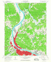
~ Saint Albans WV topo map, 1:24000 scale, 7.5 X 7.5 Minute, Historical, 1958, updated 1967
Saint Albans, West Virginia, USGS topographic map dated 1958.
Includes geographic coordinates (latitude and longitude). This topographic map is suitable for hiking, camping, and exploring, or framing it as a wall map.
Printed on-demand using high resolution imagery, on heavy weight and acid free paper, or alternatively on a variety of synthetic materials.
Topos available on paper, Waterproof, Poly, or Tyvek. Usually shipping rolled, unless combined with other folded maps in one order.
- Product Number: USGS-5414168
- Free digital map download (high-resolution, GeoPDF): Saint Albans, West Virginia (file size: 16 MB)
- Map Size: please refer to the dimensions of the GeoPDF map above
- Weight (paper map): ca. 55 grams
- Map Type: POD USGS Topographic Map
- Map Series: HTMC
- Map Verison: Historical
- Cell ID: 39212
- Scan ID: 253111
- Imprint Year: 1967
- Woodland Tint: Yes
- Aerial Photo Year: 1957
- Field Check Year: 1958
- Datum: NAD27
- Map Projection: Polyconic
- Map published by United States Geological Survey
- Map Language: English
- Scanner Resolution: 600 dpi
- Map Cell Name: Saint Albans
- Grid size: 7.5 X 7.5 Minute
- Date on map: 1958
- Map Scale: 1:24000
- Geographical region: West Virginia, United States
Neighboring Maps:
All neighboring USGS topo maps are available for sale online at a variety of scales.
Spatial coverage:
Topo map Saint Albans, West Virginia, covers the geographical area associated the following places:
- Silver Valley Estates - Sattes - Baker Park - Jefferson - Scary - Poplar Point Estates - Black Betsey - Glass Addition - Highlawn - Arborland Acres - Morgans Landing - Tyler Heights - Raymond City - Ortin Heights - Belvil Park - Poca - Roseville Addition - Rock Branch - Strawberry Heights - East Nitro - Institute - Amandaville - Marlaina Addition - Windsong Acres - Twin Rivers Mobile Home Park - Riverdale Acres - Saint Albans - Nitro - Springlea Estates - Cross Lanes - Lower Falls - Riverside Mobile Home Park - Valley Brook Mobile Home Park - Parkway Terrace - Virginia Heights
- Map Area ID: AREA38.538.375-81.875-81.75
- Northwest corner Lat/Long code: USGSNW38.5-81.875
- Northeast corner Lat/Long code: USGSNE38.5-81.75
- Southwest corner Lat/Long code: USGSSW38.375-81.875
- Southeast corner Lat/Long code: USGSSE38.375-81.75
- Northern map edge Latitude: 38.5
- Southern map edge Latitude: 38.375
- Western map edge Longitude: -81.875
- Eastern map edge Longitude: -81.75


