
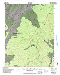
~ Paddy Knob WV topo map, 1:24000 scale, 7.5 X 7.5 Minute, Historical, 1995, updated 1998
Paddy Knob, West Virginia, USGS topographic map dated 1995.
Includes geographic coordinates (latitude and longitude). This topographic map is suitable for hiking, camping, and exploring, or framing it as a wall map.
Printed on-demand using high resolution imagery, on heavy weight and acid free paper, or alternatively on a variety of synthetic materials.
Topos available on paper, Waterproof, Poly, or Tyvek. Usually shipping rolled, unless combined with other folded maps in one order.
- Product Number: USGS-5413784
- Free digital map download (high-resolution, GeoPDF): Paddy Knob, West Virginia (file size: 15 MB)
- Map Size: please refer to the dimensions of the GeoPDF map above
- Weight (paper map): ca. 55 grams
- Map Type: POD USGS Topographic Map
- Map Series: HTMC
- Map Verison: Historical
- Cell ID: 33866
- Scan ID: 701204
- Imprint Year: 1998
- Woodland Tint: Yes
- Aerial Photo Year: 1991
- Field Check Year: 1995
- Datum: NAD27
- Map Projection: Lambert Conformal Conic
- Map published by United States Forest Service
- Map Language: English
- Scanner Resolution: 508 dpi
- Map Cell Name: Paddy Knob
- Grid size: 7.5 X 7.5 Minute
- Date on map: 1995
- Map Scale: 1:24000
- Geographical region: West Virginia, United States
Neighboring Maps:
All neighboring USGS topo maps are available for sale online at a variety of scales.
Spatial coverage:
Topo map Paddy Knob, West Virginia, covers the geographical area associated the following places:
- Bussard Cemetery - Paddy Knob Lookout Tower - Charley Ridge - Meadow Spring - Chocklett Spring - Camp Copperhead (historical) - Gragg Cemetery - Little Ridge - Gum Spring School (historical) - Dunmore Spring - Steep Pinch Ridge - Wesley Chapel School (historical) - Shinaberry Cemetery - Bridge Hollow - Big Ridge - Dilly Cemetery - Sorrel Point Ridge - Gum Branch - Hillside School (historical) - Slate Lick Knob - Shock Run - Lick Draft - Lindsay Cemetery - Big End - Gregory Ridge - Paddy Knob - Lick Points - Brushy Ridge - Left Prong Galford Run - Pine Ridge - Kent Simmons Hollow - Campground Hollow - Thorny Branch - Galford Run - Mount Pleasant School (historical) - Lower Mountain - Bird Run Campground - Bird Run - Garfield Grimes Spring - Wesley Chapel - Chestnut Ridge - Jakes Run - Moore Cemetery - Stony Run - Paddy Knob Trail - Chestnut Ridge - Buzzard Cemetery - Bear Hollow - New Hope Church - Lower Gap - Mad Sheep Ridge - Buzzard Cemetery - Big Crooked Ridge
- Map Area ID: AREA38.37538.25-79.875-79.75
- Northwest corner Lat/Long code: USGSNW38.375-79.875
- Northeast corner Lat/Long code: USGSNE38.375-79.75
- Southwest corner Lat/Long code: USGSSW38.25-79.875
- Southeast corner Lat/Long code: USGSSE38.25-79.75
- Northern map edge Latitude: 38.375
- Southern map edge Latitude: 38.25
- Western map edge Longitude: -79.875
- Eastern map edge Longitude: -79.75


