
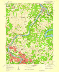
~ Morgantown North WV topo map, 1:24000 scale, 7.5 X 7.5 Minute, Historical, 1957, updated 1959
Morgantown North, West Virginia, USGS topographic map dated 1957.
Includes geographic coordinates (latitude and longitude). This topographic map is suitable for hiking, camping, and exploring, or framing it as a wall map.
Printed on-demand using high resolution imagery, on heavy weight and acid free paper, or alternatively on a variety of synthetic materials.
Topos available on paper, Waterproof, Poly, or Tyvek. Usually shipping rolled, unless combined with other folded maps in one order.
- Product Number: USGS-5413550
- Free digital map download (high-resolution, GeoPDF): Morgantown North, West Virginia (file size: 12 MB)
- Map Size: please refer to the dimensions of the GeoPDF map above
- Weight (paper map): ca. 55 grams
- Map Type: POD USGS Topographic Map
- Map Series: HTMC
- Map Verison: Historical
- Cell ID: 30235
- Scan ID: 701088
- Imprint Year: 1959
- Woodland Tint: Yes
- Aerial Photo Year: 1955
- Field Check Year: 1957
- Datum: NAD27
- Map Projection: Polyconic
- Map published by United States Geological Survey
- Map Language: English
- Scanner Resolution: 508 dpi
- Map Cell Name: Morgantown North
- Grid size: 7.5 X 7.5 Minute
- Date on map: 1957
- Map Scale: 1:24000
- Geographical region: West Virginia, United States
Neighboring Maps:
All neighboring USGS topo maps are available for sale online at a variety of scales.
Spatial coverage:
Topo map Morgantown North, West Virginia, covers the geographical area associated the following places:
- Stewartstown - Rosedale - Woodburn - Tanglewood - Chestnut Ridge - Seneca - West Point Marion - Virginia Manor - Oakview - Point Marion - Star City - Davidson - Sabraton - Evansdale - Bertha Hill - Riverside - Morgan Heights - Fort Martin - Pierpont - West Van Voorhis - The Flatts - Randall - Suncrest - Granville - Dunkard - Jerome Park - Wiles Hill - Nilan - Baker Ridge - Suncrest Lake - Fieldcrest - The Mileground - Walnut Hill - North Hills - Brewer Hill - Fairmor - Van Voorhis - Sunnyside - Blosser Hill - Westover - Morgantown - McKinley Hill - Canyon - Jaco - Maidsville - Easton - Park Hills - Hoard - Braewick Woods - Pineridge North
- Map Area ID: AREA39.7539.625-80-79.875
- Northwest corner Lat/Long code: USGSNW39.75-80
- Northeast corner Lat/Long code: USGSNE39.75-79.875
- Southwest corner Lat/Long code: USGSSW39.625-80
- Southeast corner Lat/Long code: USGSSE39.625-79.875
- Northern map edge Latitude: 39.75
- Southern map edge Latitude: 39.625
- Western map edge Longitude: -80
- Eastern map edge Longitude: -79.875


