
~ Yakima WA topo map, 1:250000 scale, 1 X 2 Degree, Historical, 1961
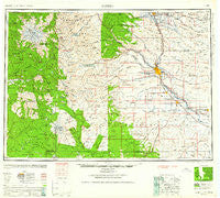
Yakima, Washington, USGS topographic map dated 1961.
Includes geographic coordinates (latitude and longitude). This topographic map is suitable for hiking, camping, and exploring, or framing it as a wall map.
Printed on-demand using high resolution imagery, on heavy weight and acid free paper, or alternatively on a variety of synthetic materials.
Topos available on paper, Waterproof, Poly, or Tyvek. Usually shipping rolled, unless combined with other folded maps in one order.
- Product Number: USGS-5411564
- Free digital map download (high-resolution, GeoPDF): Yakima, Washington (file size: 17 MB)
- Map Size: please refer to the dimensions of the GeoPDF map above
- Weight (paper map): ca. 55 grams
- Map Type: POD USGS Topographic Map
- Map Series: HTMC
- Map Verison: Historical
- Cell ID: 69111
- Scan ID: 244824
- Woodland Tint: Yes
- Aerial Photo Year: 1945
- Datum: NAD27
- Map Projection: Transverse Mercator
- Map published by United States Geological Survey
- Map Language: English
- Scanner Resolution: 600 dpi
- Map Cell Name: Yakima
- Grid size: 1 X 2 Degree
- Date on map: 1961
- Map Scale: 1:250000
- Geographical region: Washington, United States
Neighboring Maps:
All neighboring USGS topo maps are available for sale online at a variety of scales.
Spatial coverage:
Topo map Yakima, Washington, covers the geographical area associated the following places:
- Parker - Wiley City - Summitview - Regal - Wesley Junction - Kittitas - Tieton - Weikel - Washington Park - American River - White Swan - Ahtanum - Pomona Heights - Cheviot - Tampico - Satus - Yethonat - Emerald - Terrace Heights - Sunrise - Berry Patch - Umtanum - Boylston - Gromore - Sawyer - East Kittitas - Fruitvale - Siler - Wenas - Nile - Birchfield - Willy Dick Crossing - Venner - Rupple - Holmes - Harwood - Tietonview Grange - Harrah - Wymer - Alfalfa - West Valley - Moxee City - Wapato - Outlook - East Selah - Holtzinger - Elliott Ave - Pinecliff - Goose Prairie - Granger - Sunnyside - Thrall - Brace - Buena - Donald - Longmire - Liberty - Gleed - Silver Brook - Paradise - Hillside Siding - Ellensburg - Yakima - Eschbach - Selah - Glenwood - Randle - Nass - Flint - Farron - Edgemont - Zillah - Union Gap - Naches - Toppenish - Nisqually Vista - Packwood - Tasker - Silver Beach - Renslow - Rye - Bluelight - Vance (not official) - Cliffdell - Cowiche - Pomona - Cora - Midvale - Tire Junction - South Broadway - Doris - Ashue - Rimrock - Roza - Parrott Crossing - Brownstown - Artesian
- Map Area ID: AREA4746-122-120
- Northwest corner Lat/Long code: USGSNW47-122
- Northeast corner Lat/Long code: USGSNE47-120
- Southwest corner Lat/Long code: USGSSW46-122
- Southeast corner Lat/Long code: USGSSE46-120
- Northern map edge Latitude: 47
- Southern map edge Latitude: 46
- Western map edge Longitude: -122
- Eastern map edge Longitude: -120


