
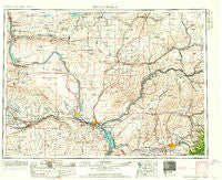
~ Walla Walla WA topo map, 1:250000 scale, 1 X 2 Degree, Historical, 1953, updated 1964
Walla Walla, Washington, USGS topographic map dated 1953.
Includes geographic coordinates (latitude and longitude). This topographic map is suitable for hiking, camping, and exploring, or framing it as a wall map.
Printed on-demand using high resolution imagery, on heavy weight and acid free paper, or alternatively on a variety of synthetic materials.
Topos available on paper, Waterproof, Poly, or Tyvek. Usually shipping rolled, unless combined with other folded maps in one order.
- Product Number: USGS-5411552
- Free digital map download (high-resolution, GeoPDF): Walla Walla, Washington (file size: 18 MB)
- Map Size: please refer to the dimensions of the GeoPDF map above
- Weight (paper map): ca. 55 grams
- Map Type: POD USGS Topographic Map
- Map Series: HTMC
- Map Verison: Historical
- Cell ID: 69085
- Scan ID: 244506
- Imprint Year: 1964
- Woodland Tint: Yes
- Edit Year: 1963
- Field Check Year: 1953
- Datum: Unstated
- Map Projection: Transverse Mercator
- Map published by United States Geological Survey
- Map Language: English
- Scanner Resolution: 600 dpi
- Map Cell Name: Walla Walla
- Grid size: 1 X 2 Degree
- Date on map: 1953
- Map Scale: 1:250000
- Geographical region: Washington, United States
Neighboring Maps:
All neighboring USGS topo maps are available for sale online at a variety of scales.
Spatial coverage:
Topo map Walla Walla, Washington, covers the geographical area associated the following places:
- Nancy - Levey - Whitman - Russell - Richland Junction - Walker - Willa - Jericho - Fletcher - Grandview - Edwards - Harder - Othello - Mathews Corner - Sapolil - Schwana - Waitsburg - Le Grow - Geneva Junction - Robinson - Riverview - Bolles - Richland Y - Harsha - Attalia - Ruth - Lamar - Pasco West - Horse Heaven - Ralston - Estes - Sperry - Walla Walla - Mojonnier - Burr - Adkins - Helen - Koren - Gordon - Gibbon - Burbank Heights - Smyrna - Ethel - Novara - Blacks Corner - Low Gap - Minnick - Edna - Five Corners - Basin City - Eltopia - Schlomer - Riparia - Slater - Blackrock (historical) - Magallon - Langdon - Perry - Ginger - Thomas - Reese - Corfu - Pizarro - Page - Lowden - Chaffee - Two Rivers - Harvey - Ash - Curry - Windust - Port of Kennewick - Lichty - Burbank - Badger - Villard Junction - Eastman - Sheffler - Scott - Bemis - Wallula - West Pasco - Welland - McAdam - Wanapum Village - Menoken - Mabton - Whitstran - Mack - Thiel - White Bluffs - Pedigo - West Richland - Yellepit - Ruxby - Kooskooskie - Vista - Royal City - Beverly - Five Points
- Map Area ID: AREA4746-120-118
- Northwest corner Lat/Long code: USGSNW47-120
- Northeast corner Lat/Long code: USGSNE47-118
- Southwest corner Lat/Long code: USGSSW46-120
- Southeast corner Lat/Long code: USGSSE46-118
- Northern map edge Latitude: 47
- Southern map edge Latitude: 46
- Western map edge Longitude: -120
- Eastern map edge Longitude: -118


