
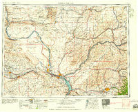
~ Walla Walla WA topo map, 1:250000 scale, 1 X 2 Degree, Historical, 1958
Walla Walla, Washington, USGS topographic map dated 1958.
Includes geographic coordinates (latitude and longitude). This topographic map is suitable for hiking, camping, and exploring, or framing it as a wall map.
Printed on-demand using high resolution imagery, on heavy weight and acid free paper, or alternatively on a variety of synthetic materials.
Topos available on paper, Waterproof, Poly, or Tyvek. Usually shipping rolled, unless combined with other folded maps in one order.
- Product Number: USGS-5411550
- Free digital map download (high-resolution, GeoPDF): Walla Walla, Washington (file size: 19 MB)
- Map Size: please refer to the dimensions of the GeoPDF map above
- Weight (paper map): ca. 55 grams
- Map Type: POD USGS Topographic Map
- Map Series: HTMC
- Map Verison: Historical
- Cell ID: 69085
- Scan ID: 244505
- Woodland Tint: Yes
- Field Check Year: 1953
- Datum: Unstated
- Map Projection: Transverse Mercator
- Map published by United States Geological Survey
- Map Language: English
- Scanner Resolution: 600 dpi
- Map Cell Name: Walla Walla
- Grid size: 1 X 2 Degree
- Date on map: 1958
- Map Scale: 1:250000
- Geographical region: Washington, United States
Neighboring Maps:
All neighboring USGS topo maps are available for sale online at a variety of scales.
Spatial coverage:
Topo map Walla Walla, Washington, covers the geographical area associated the following places:
- Calhounville - Mattawa - West Richland - Page - Waiilatpo (historical) - Givens Corner - Clyde - Blacks Corner - Schwana - Whitstran - Five Points - Rulo - Paddock - Baker-Langdon - Hedges - Washtucna - Magallon - Babcock - Edna - Warden - Ankeny - Thavis - Tracy - Ruth - Pedigo - Wallula - Pickard - Hadley - Edwards - Eastman - Novara - Whitman - Eltopia - Port Kelley - Beatrice - Wacota - Wahluke - Coppei - Schlomer - Cunningham - Harsha - Fletcher - Hatch - Harvey - Long - East White Bluffs - Ruxby - Ainsworth Junction - Prescott - Vista - Horse Heaven - North Prosser - Redd - Garrett - Harder - Riverview - College Place - Susie - Royal City - Chew - Gibbon - Cactus - Wallula Junction - Willa - Pierce - Dixie - Valley Grove - Welland - Ash - Dixie Crossing - Roxboro - Badger - Wanapum Village - Varna - Grange City (historical) - Tompkins - Minnick - Harbert - Thomas - Stateline - Lowden - Kiona - Walker - Desert Aire - Adkins - Elwood - Providence - Lee - Le Grow - Mack - Lamar - Farrington - May Junction - Pasco - Kooskooskie - Ennis - Mathews Corner - Chaffee - Audrey - Beverly
- Map Area ID: AREA4746-120-118
- Northwest corner Lat/Long code: USGSNW47-120
- Northeast corner Lat/Long code: USGSNE47-118
- Southwest corner Lat/Long code: USGSSW46-120
- Southeast corner Lat/Long code: USGSSE46-118
- Northern map edge Latitude: 47
- Southern map edge Latitude: 46
- Western map edge Longitude: -120
- Eastern map edge Longitude: -118


