
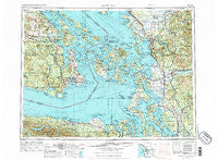
~ Victoria WA topo map, 1:250000 scale, 1 X 2 Degree, Historical, 1957, updated 1976
Victoria, Washington, USGS topographic map dated 1957.
Includes geographic coordinates (latitude and longitude). This topographic map is suitable for hiking, camping, and exploring, or framing it as a wall map.
Printed on-demand using high resolution imagery, on heavy weight and acid free paper, or alternatively on a variety of synthetic materials.
Topos available on paper, Waterproof, Poly, or Tyvek. Usually shipping rolled, unless combined with other folded maps in one order.
- Product Number: USGS-5411548
- Free digital map download (high-resolution, GeoPDF): Victoria, Washington (file size: 29 MB)
- Map Size: please refer to the dimensions of the GeoPDF map above
- Weight (paper map): ca. 55 grams
- Map Type: POD USGS Topographic Map
- Map Series: HTMC
- Map Verison: Historical
- Cell ID: 75040
- Scan ID: 244480
- Imprint Year: 1976
- Woodland Tint: Yes
- Visual Version Number: 2
- Aerial Photo Year: 1973
- Edit Year: 1974
- Field Check Year: 1957
- Datum: Unstated
- Map Projection: Transverse Mercator
- Map published by: Military, Other
- Map Language: English
- Scanner Resolution: 600 dpi
- Map Cell Name: Victoria
- Grid size: 1 X 2 Degree
- Date on map: 1957
- Map Scale: 1:250000
- Geographical region: Washington, United States
Neighboring Maps:
All neighboring USGS topo maps are available for sale online at a variety of scales.
Spatial coverage:
Topo map Victoria, Washington, covers the geographical area associated the following places:
- Glen Cove - Pine Street Mobile Home Park - Argyle - Juniper Beach - Portal Creek Mobile Home Park - La Tierra Mobile Home Park - Lower Elwha - Plaza Mobile Home Park - Elwha - Sunny Shores - Nooksack - West Beach - Anacortes - Firwest Mobile Home Park - Forest Ridge - Swinomish Village - Buckhorn - Day Creek - Fort Flagler - Geneva - Parkwood Manor Mobile Home Park - McGees (historical) - South Beach - Port Arthur (historical) - Clear Lake - Van Fleet Mobile Home Park - Cokedale - Friday Harbor - Cedar Grove Mobile Home Park - Lake Padden Estates Mobile Home Park - Neptune Beach - Duncans Mobile Home Park - Autumn Lane Mobile Home Park - Sunnyside Mobile Court - South End Mobile Estates - Bay View - Sunset - Chimacum - Prairie Center - Moores Mobile Manor - Nelson Mobile Home Park - Hadlock Adult Village Mobile Home Park - Terry Mobile Park - Dewey - Roche Harbor - Kulshan - Port Crescent - Western Village Mobile Estates - Prairie - Lamplighter Mobile Park - Port Discovery - Everson - Bay View Mobile Home Park - Twin Cedar Mobile Park - Baker Heights - Lake Cavanaugh - King Hill - Wahl - Urban - North Bay Mobile Home Park - Maple Grove - Guemes - Florence - Lake Stevens - Sands 55 Plus Mobile Park - Spruce West Mobile Home Park - Columbia - Lazy Acres Mobile Home Park - Hawkeye Mobile Home Park - Burlington - Saxon - Cicero - Comar - Larson Mill - Evergreen Mobile Home Park - John Sam Lake - Kickerville - Country Mobile Home Court - Juniper Mobile Estates - Langley - Green Acres Mobile Estates - Larsen Mobile Manor - Samish Island - Dukes Mobile Home Park - Birch Bay Resort Mobile Home Park - Fairhaven - Hartford - Parkwood Mobile Home Community - Mobile Manor - Cedar Hills Mobile Home Park - Shadow - Islandale - Colonial Mobile Home Park - East Stanwood - Laurel - Agnew Mobile Home Park - Pleasant Valley - Saratoga Shores - Prevost - Peters Mobile Home Park
- Map Area ID: AREA4948-124-122
- Northwest corner Lat/Long code: USGSNW49-124
- Northeast corner Lat/Long code: USGSNE49-122
- Southwest corner Lat/Long code: USGSSW48-124
- Southeast corner Lat/Long code: USGSSE48-122
- Northern map edge Latitude: 49
- Southern map edge Latitude: 48
- Western map edge Longitude: -124
- Eastern map edge Longitude: -122


