
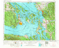
~ Victoria WA topo map, 1:250000 scale, 1 X 2 Degree, Historical, 1957, updated 1966
Victoria, Washington, USGS topographic map dated 1957.
Includes geographic coordinates (latitude and longitude). This topographic map is suitable for hiking, camping, and exploring, or framing it as a wall map.
Printed on-demand using high resolution imagery, on heavy weight and acid free paper, or alternatively on a variety of synthetic materials.
Topos available on paper, Waterproof, Poly, or Tyvek. Usually shipping rolled, unless combined with other folded maps in one order.
- Product Number: USGS-5411544
- Free digital map download (high-resolution, GeoPDF): Victoria, Washington (file size: 19 MB)
- Map Size: please refer to the dimensions of the GeoPDF map above
- Weight (paper map): ca. 55 grams
- Map Type: POD USGS Topographic Map
- Map Series: HTMC
- Map Verison: Historical
- Cell ID: 75040
- Scan ID: 244478
- Imprint Year: 1966
- Woodland Tint: Yes
- Aerial Photo Year: 1956
- Edit Year: 1966
- Field Check Year: 1957
- Datum: Unstated
- Map Projection: Transverse Mercator
- Map published by United States Army Corps of Engineers
- Map published by United States Army
- Map Language: English
- Scanner Resolution: 600 dpi
- Map Cell Name: Victoria
- Grid size: 1 X 2 Degree
- Date on map: 1957
- Map Scale: 1:250000
- Geographical region: Washington, United States
Neighboring Maps:
All neighboring USGS topo maps are available for sale online at a variety of scales.
Spatial coverage:
Topo map Victoria, Washington, covers the geographical area associated the following places:
- Al's Mobile Home Park - Cottonwood Beach - Lake Ki Mobile Home Park - Nooksack Salmon Hatchery - Clipper - Little Mountain Estates Mobile Home Park - New Utsaladdy - Marysville - Dewey - Florence - Argyle - Delta Junction - Tulalip - Colonial Mobile Home Park - Sharpes Corner - Hendrickson Heritage Mobile Home Park - Wagon Wheel Mobile Home Park - Priest Point - Richardson - Dean Manor - Mountain View Estates Mobile Home Park - Custer - Mirror Lake - Mabana - John Sam Lake - Alderwood - Shadow - Pilchuck - La Tierra Mobile Home Park - Evergreen Mobile Home Park - Limestone Junction - Mobile Haven Mobile Home Park - Friday Harbor - Birch Bay - Leary - Bow - Sunset Terrace - Eagle Point Mobile Home Park - Van Wyck - Minkler - Bryant - Silvana Terraces - Happy Valley - Burlington - Greenwood - Little Oklahoma - Sterling - Langley - Lake Cavanaugh - Riverside - Atlanta (historical) - Mobile Manor - Kickerville - Lake Samish Terrace Mobile Home Park - Haynie - Alger - Equality - Chuckanut Village - View Mont Mobile Park - Strandell - Burlington Hill Estates Mobile Home Park - Four Corners Olympic Mobile Village - Mountain View Mobile Park - Bel Air Village Trailer Court - Oak Hollow Mobile Home Park - Sea Acre - Cedar Hills Mobile Home Park - Blue Canyon - Birchwood - Oak Harbor - Glen Cove - Kendall - River Road - Parkway Village Mobile Home Park - Doran - Samish Island - James Street Estates Mobile Home Park - Lopez - Decatur - Edison - Happy Valley - Bay View - North Beach - Lona Beach - Port Discovery - Everson - Pleasant Valley - Glenwood Mobile Estates - Joyce - Portal Way Mobile Village - Stanwood - Hyland - Beverly Beach - Duncans Mobile Home Park - Camp Diana - Port Hadlock - Deer Harbor - Hoogdal - Welcome - Coveland
- Map Area ID: AREA4948-124-122
- Northwest corner Lat/Long code: USGSNW49-124
- Northeast corner Lat/Long code: USGSNE49-122
- Southwest corner Lat/Long code: USGSSW48-124
- Southeast corner Lat/Long code: USGSSE48-122
- Northern map edge Latitude: 49
- Southern map edge Latitude: 48
- Western map edge Longitude: -124
- Eastern map edge Longitude: -122


