
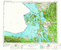
~ Victoria WA topo map, 1:250000 scale, 1 X 2 Degree, Historical, 1957, updated 1960
Victoria, Washington, USGS topographic map dated 1957.
Includes geographic coordinates (latitude and longitude). This topographic map is suitable for hiking, camping, and exploring, or framing it as a wall map.
Printed on-demand using high resolution imagery, on heavy weight and acid free paper, or alternatively on a variety of synthetic materials.
Topos available on paper, Waterproof, Poly, or Tyvek. Usually shipping rolled, unless combined with other folded maps in one order.
- Product Number: USGS-5411542
- Free digital map download (high-resolution, GeoPDF): Victoria, Washington (file size: 16 MB)
- Map Size: please refer to the dimensions of the GeoPDF map above
- Weight (paper map): ca. 55 grams
- Map Type: POD USGS Topographic Map
- Map Series: HTMC
- Map Verison: Historical
- Cell ID: 75040
- Scan ID: 244477
- Imprint Year: 1960
- Woodland Tint: Yes
- Field Check Year: 1957
- Datum: Unstated
- Map Projection: Transverse Mercator
- Map published by United States Army Corps of Engineers
- Map published by United States Army
- Map Language: English
- Scanner Resolution: 600 dpi
- Map Cell Name: Victoria
- Grid size: 1 X 2 Degree
- Date on map: 1957
- Map Scale: 1:250000
- Geographical region: Washington, United States
Neighboring Maps:
All neighboring USGS topo maps are available for sale online at a variety of scales.
Spatial coverage:
Topo map Victoria, Washington, covers the geographical area associated the following places:
- Port Angeles - Snee Oosh - Shelter Bay - Swinomish Village - Waldron - Van Zandt - Tulalip Bay - Cedarville - Similk Beach - Evergreen Mobile Home Park - Saxon - Indian Beach - Cedar Glen Mobile Home Park - Big Lake - Burlington Mobile Park - Equality - Gulfaire Mobile Villa - Rosario - Greenbank - Stanwood - Lakeway Mobile Estates - Port Williams - Wickersham - Day Creek - Juniper Mobile Estates - Port Crescent - Columbia - Bell Hill - Little Oklahoma - Thornwood - Edgewater Resort and Trailer Park - Belfast - Cedar Lane Mobile Home Park - Weallup Lake - Rexville - Edison Station - Cottonwood Beach - Harbor Center - Bay View - King Hill - Rena - Langley - Clearbrook - Plaza Mobile Home Park - Marketown - Skagit City - Oaks Mobile Home Park - Chuckanut Village - Sterling - Glen Cove - Dewey - Agnew Mobile Home Park - Custer - Mount Vernon - Gibraltar - Getchell - Robin Lane Mobile Home Park - Olga - Snug Harbor - Neptune Beach - Riverside - Sisco - Mountain View Estates Mobile Home Park - Town and Country Mobile Home Park - Manthey's Country Mobile Home Park - Allen - North Stanwood - Everson Mobile Home Estates - Leary - Swantown - Lake McMurray - Yacht Haven - Smokey Point Mobile Home Park - Geneva - Silvana Terraces - Port Hadlock - Friday Harbor - Baby Island Heights - Eagle Mobile Home Park - Hilltop Haven Mobile Home Park - Bryant - Penn Cove Park - Cresthaven Mobile Home Park - Moores Mobile Manor - Beverly Beach - Fort Knox Mobile Home Park - Dungeness - Bay View Mobile Home Park - Sobey - Doe Bay - Duncans Mobile Home Park - Lake Padden Estates Mobile Home Park - Lake Ketchum - Mountain View Mobile Park - Camp Diana - Airway Mobile Home Park - Chuckanut - Country Mobile Home Court - Elwha - Birch Bay
- Map Area ID: AREA4948-124-122
- Northwest corner Lat/Long code: USGSNW49-124
- Northeast corner Lat/Long code: USGSNE49-122
- Southwest corner Lat/Long code: USGSSW48-124
- Southeast corner Lat/Long code: USGSSE48-122
- Northern map edge Latitude: 49
- Southern map edge Latitude: 48
- Western map edge Longitude: -124
- Eastern map edge Longitude: -122


