
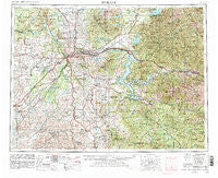
~ Spokane WA topo map, 1:250000 scale, 1 X 2 Degree, Historical, 1955, updated 1980
Spokane, Washington, USGS topographic map dated 1955.
Includes geographic coordinates (latitude and longitude). This topographic map is suitable for hiking, camping, and exploring, or framing it as a wall map.
Printed on-demand using high resolution imagery, on heavy weight and acid free paper, or alternatively on a variety of synthetic materials.
Topos available on paper, Waterproof, Poly, or Tyvek. Usually shipping rolled, unless combined with other folded maps in one order.
- Product Number: USGS-5411540
- Free digital map download (high-resolution, GeoPDF): Spokane, Washington (file size: 26 MB)
- Map Size: please refer to the dimensions of the GeoPDF map above
- Weight (paper map): ca. 55 grams
- Map Type: POD USGS Topographic Map
- Map Series: HTMC
- Map Verison: Historical
- Cell ID: 75035
- Scan ID: 243956
- Imprint Year: 1980
- Woodland Tint: Yes
- Aerial Photo Year: 1977
- Edit Year: 1980
- Field Check Year: 1955
- Datum: NAD27
- Map Projection: Transverse Mercator
- Map published by: Military, Other
- Map Language: English
- Scanner Resolution: 600 dpi
- Map Cell Name: Spokane
- Grid size: 1 X 2 Degree
- Date on map: 1955
- Map Scale: 1:250000
- Geographical region: Washington, United States
Neighboring Maps:
All neighboring USGS topo maps are available for sale online at a variety of scales.
Spatial coverage:
Topo map Spokane, Washington, covers the geographical area associated the following places:
- Plummer Junction - Robinson - Clarkia - Excelsior Beach - McCoy - Emida - Freedom - Babb - McGuire - Rockford - Steamboat (historical) - Clayton - Lancaster - Hamann Corner - Spokane - Dartford - Seltice - Donahue - Fairwood - Bellgrove - Wright (historical) - Eden - Saint Maries - Herrick - Balder - Clayton Meadows Mobile Home Park - Hayford - Liberty Lake - Pinehurst - Chł'ach'alqw Landing - Elizabeth Park - Mashburn - Waverly - Darknell - Chatcolet - Greenacres - Belmont - Sweeney - Atlas - Kellogg - Moab - Conkling Park - Nelson (historical) - Warner - Seven Mile - North Vista Mobile Home Park - Emerald Creek - Wardner - Geiger Heights - Tekoa - Mount Hope - Flaig - Masonia (historical) - Post Falls - Thornton - Veradale - Coeur d'Alene Junction - Manito - Mica - Elk Creek - Fairbanks - Orchard Prairie - Espanola - Howelltown - Peone - Garfield - Millwood - Stringtown - Kenova - Elanor - Yardley - Crabtree - Harrison - State Line Village - Rosalia - Echo Beach - Willard - Rathdrum - Fairchild - Willard - Page - Springston - Buckeye - Cashup - Lotus - Huntley - Cardwell - Saint John - Tyson Creek Station - Edwall - Setters - English Point - East Spokane - Alpha (historical) - Bradley - East Cheney - Chatnwaqhi'łpm Grove - Juno - Scribner - Bayview
- Map Area ID: AREA4847-118-116
- Northwest corner Lat/Long code: USGSNW48-118
- Northeast corner Lat/Long code: USGSNE48-116
- Southwest corner Lat/Long code: USGSSW47-118
- Southeast corner Lat/Long code: USGSSE47-116
- Northern map edge Latitude: 48
- Southern map edge Latitude: 47
- Western map edge Longitude: -118
- Eastern map edge Longitude: -116


