
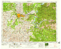
~ Spokane WA topo map, 1:250000 scale, 1 X 2 Degree, Historical, 1958
Spokane, Washington, USGS topographic map dated 1958.
Includes geographic coordinates (latitude and longitude). This topographic map is suitable for hiking, camping, and exploring, or framing it as a wall map.
Printed on-demand using high resolution imagery, on heavy weight and acid free paper, or alternatively on a variety of synthetic materials.
Topos available on paper, Waterproof, Poly, or Tyvek. Usually shipping rolled, unless combined with other folded maps in one order.
- Product Number: USGS-5411536
- Free digital map download (high-resolution, GeoPDF): Spokane, Washington (file size: 25 MB)
- Map Size: please refer to the dimensions of the GeoPDF map above
- Weight (paper map): ca. 55 grams
- Map Type: POD USGS Topographic Map
- Map Series: HTMC
- Map Verison: Historical
- Cell ID: 75035
- Scan ID: 243954
- Woodland Tint: Yes
- Field Check Year: 1955
- Datum: Unstated
- Map Projection: Transverse Mercator
- Map published by United States Army Corps of Engineers
- Map published by United States Army
- Map Language: English
- Scanner Resolution: 600 dpi
- Map Cell Name: Spokane
- Grid size: 1 X 2 Degree
- Date on map: 1958
- Map Scale: 1:250000
- Geographical region: Washington, United States
Neighboring Maps:
All neighboring USGS topo maps are available for sale online at a variety of scales.
Spatial coverage:
Topo map Spokane, Washington, covers the geographical area associated the following places:
- Sanders - McGuire - Cardwell - Irwin - Gravelles - Garfield - Millwood - Orchard Avenue - Buckeye - Cashup - Little Falls - Kellogg - Herrick - Balder - Tyler - Hayden - Valleyford - Scribner - Sturgeon - Ramsey - Gibbs - Babb - Tyson Creek Station - Coey - Thornton - Highland - Cheney - Moab - Rockford - Wellpinit - Worley - Manito - Parkwater - Chatcolet - State Line Village - Freeman - Fishtrap - North Pole - Meadowhurst - Austin - Bradley - Plaza - Riverdale - Medical Lake - Pine Creek - Glenrose - Emerald Creek - Twinlow - Mozart - Pine City - Elanor - Nelson (historical) - Mica - Lamont - Wardner - Canyon - Alder Creek - West Fairfield - Hutton Settlement - Colbert - Clayton - Lotus - Echo Beach - Fir Grove - Ford - Town and Country - Tekoa - Spokane Valley - Plummer Junction - Rocky Point - Page - Renfrew - Veradale - Lakeview - Rose Lake - Clarkia - Edwall - Pocono - Marble Creek - Spangle - Willard - Lakeland Village - Freedom - Kingston - Springston - Medimont - Tensed - Walters - Milltown - Ewan - Steamboat Rocks - Saint Joe - Rover - Fairwood - Rockaway Beach - Dalton Gardens - East Farms - Mead - Blackwell - East Cheney
- Map Area ID: AREA4847-118-116
- Northwest corner Lat/Long code: USGSNW48-118
- Northeast corner Lat/Long code: USGSNE48-116
- Southwest corner Lat/Long code: USGSSW47-118
- Southeast corner Lat/Long code: USGSSE47-116
- Northern map edge Latitude: 48
- Southern map edge Latitude: 47
- Western map edge Longitude: -118
- Eastern map edge Longitude: -116


