
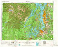
~ Seattle WA topo map, 1:250000 scale, 1 X 2 Degree, Historical, 1958, updated 1966
Seattle, Washington, USGS topographic map dated 1958.
Includes geographic coordinates (latitude and longitude). This topographic map is suitable for hiking, camping, and exploring, or framing it as a wall map.
Printed on-demand using high resolution imagery, on heavy weight and acid free paper, or alternatively on a variety of synthetic materials.
Topos available on paper, Waterproof, Poly, or Tyvek. Usually shipping rolled, unless combined with other folded maps in one order.
- Product Number: USGS-5411530
- Free digital map download (high-resolution, GeoPDF): Seattle, Washington (file size: 23 MB)
- Map Size: please refer to the dimensions of the GeoPDF map above
- Weight (paper map): ca. 55 grams
- Map Type: POD USGS Topographic Map
- Map Series: HTMC
- Map Verison: Historical
- Cell ID: 72248
- Scan ID: 243645
- Imprint Year: 1966
- Woodland Tint: Yes
- Edit Year: 1965
- Field Check Year: 1958
- Datum: Unstated
- Map Projection: Transverse Mercator
- Map published by United States Army Corps of Engineers
- Map published by United States Army
- Map Language: English
- Scanner Resolution: 600 dpi
- Map Cell Name: Seattle
- Grid size: 1 X 2 Degree
- Date on map: 1958
- Map Scale: 1:250000
- Geographical region: Washington, United States
Neighboring Maps:
All neighboring USGS topo maps are available for sale online at a variety of scales.
Spatial coverage:
Topo map Seattle, Washington, covers the geographical area associated the following places:
- Riverside Mobile Estates - Hilltop - Banner - Seabeck - Wedgwood - Cedar Grove Mobile Home Park - Heritage Mobile Home Park - Summerville Estates Mobile Home Park - Bonel Mobile Manor - Martell Mobile Manor - Herron - Kennard Corner - Wilkeson Gardens Mobile Home Park - Royalwood Mobile Home Estates - Whispering Firs Mobile Home Park - Dewatto - Mint Grove - Parkwood Lane Mobile Home Park - Lakeridge - York - Halcyon Mobile Home Park - Fletcher Bay - Grace - Cedarhurst - Holly Park - Riverside Mobile Home Park - Lynwood Center - East Seattle - Grapeview - SeaTac - O'Brien - Earlmont - The Firs Mobile Home Park - Orting - Oakridge Manor Mobile Home Park - Fern Heath - Silvercrest Mobile Home Park - Hawley - Cedarbrook Mobile Home Park - High Valley - Lynnwood Mobile Park - South Snohomish - Shady Glen Mobile Home Park - Sunnydale Mobile Home Park - Sherman Heights - Lakewood Mobile Home Park - Warrenville - Discovery Junction - Colby - Country Mobile Estates - Cromwell - North Broadway - Lawters Beach - Skylark Village Mobile Home Park - Camelot Mobile Estates - Sunset Terrace Mobile Home Park - Maxwelton - Serene - West Park - Buenna - Schneiders Prairie - Orillia - Woodlawn - Fairmont - Garden City - Beachcrest - Kingsbury East Mobile Home Park - Lakewood - Kamilche - Beaver Valley - Rayville - Sand Point - Bromart - Rose Point - Zenith - Sammamish - Delridge - Maple Lane Mobile Home Court - Sunrise Manor Mobile Home Park - Hunts Point - Creosote - Bridgehaven - Sunrise Beach - Magnolia Bluff - Jovita - Hollywood - Tamill - Tacoma Junction - Laurelhurst - Canyon Heights Mobile Home Park - Thomas - Benson Hill - Halo Mobile Home Park - Aberdeen Gardens - Ronald - Mobile Country Club - Martha Lake - Burton - Cedar View - Detroit (historical)
- Map Area ID: AREA4847-124-122
- Northwest corner Lat/Long code: USGSNW48-124
- Northeast corner Lat/Long code: USGSNE48-122
- Southwest corner Lat/Long code: USGSSW47-124
- Southeast corner Lat/Long code: USGSSE47-122
- Northern map edge Latitude: 48
- Southern map edge Latitude: 47
- Western map edge Longitude: -124
- Eastern map edge Longitude: -122


