
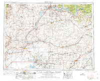
~ Ritzville WA topo map, 1:250000 scale, 1 X 2 Degree, Historical, 1953, updated 1974
Ritzville, Washington, USGS topographic map dated 1953.
Includes geographic coordinates (latitude and longitude). This topographic map is suitable for hiking, camping, and exploring, or framing it as a wall map.
Printed on-demand using high resolution imagery, on heavy weight and acid free paper, or alternatively on a variety of synthetic materials.
Topos available on paper, Waterproof, Poly, or Tyvek. Usually shipping rolled, unless combined with other folded maps in one order.
- Product Number: USGS-5411520
- Free digital map download (high-resolution, GeoPDF): Ritzville, Washington (file size: 19 MB)
- Map Size: please refer to the dimensions of the GeoPDF map above
- Weight (paper map): ca. 55 grams
- Map Type: POD USGS Topographic Map
- Map Series: HTMC
- Map Verison: Historical
- Cell ID: 68988
- Scan ID: 243471
- Imprint Year: 1974
- Woodland Tint: Yes
- Edit Year: 1965
- Field Check Year: 1953
- Datum: Unstated
- Map Projection: Transverse Mercator
- Map published by United States Army Corps of Engineers
- Map published by United States Army
- Map Language: English
- Scanner Resolution: 600 dpi
- Map Cell Name: Ritzville
- Grid size: 1 X 2 Degree
- Date on map: 1953
- Map Scale: 1:250000
- Geographical region: Washington, United States
Neighboring Maps:
All neighboring USGS topo maps are available for sale online at a variety of scales.
Spatial coverage:
Topo map Ritzville, Washington, covers the geographical area associated the following places:
- Mondovi - Palisades - Alstown - Packard - Soap Lake - Grand Coulee - Delano Heights - Lakeview - Lauer - Farmer - Lone Pine - Omans - Adco - Bagdad Junction - Apple Acres Mobile Village - Crater - Sims Corner - Barham - Bacon - Ashby - Coulee Dam - Atwood - Rocklyn - Fordair - Naylor - Electric City - Moody - Leahy - Lincoln - Creston - Crown Point Vista - Paxton - Bassett Junction - Marcellus - Okanogan City (historical) - Tokio - Laing - Carlmar - Withrow - Mason City - Weber - Earl - Sherman - Jantz - Miles - Reiman - Winchester - Baird (historical) - Teske - Bluestem - Moses Lake - East Heights - Wilson Creek - Lamona - Harrington - Mason City (historical) - Warden Hutterian Brethren - Mud Spring - Osborne - Gloyd - Irby - Howard - Cascade Valley - McDonald - Westlake - Nemo - Schoonover - Paha - George - Downs - Touhey - Sieler - Pifer - Matthiesen (historical) - Hillcrest - Marlin - Lamoine - Hesseltine - Stratford - Wheeler - Fort Spokane - Beebe - Odessa - Palm Lake - McCarteney - Lakeview Park - Emden - Fairview - Saint Hubert (historical) - Hanson - Wilbur - Ritell - Starr - Davenport - Hartline - Jameson (historical) - Almira - Azwell - Quincy - Seven Bays
- Map Area ID: AREA4847-120-118
- Northwest corner Lat/Long code: USGSNW48-120
- Northeast corner Lat/Long code: USGSNE48-118
- Southwest corner Lat/Long code: USGSSW47-120
- Southeast corner Lat/Long code: USGSSE47-118
- Northern map edge Latitude: 48
- Southern map edge Latitude: 47
- Western map edge Longitude: -120
- Eastern map edge Longitude: -118


