
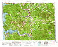
~ Hoquiam WA topo map, 1:250000 scale, 1 X 2 Degree, Historical, 1962, updated 1962
Hoquiam, Washington, USGS topographic map dated 1962.
Includes geographic coordinates (latitude and longitude). This topographic map is suitable for hiking, camping, and exploring, or framing it as a wall map.
Printed on-demand using high resolution imagery, on heavy weight and acid free paper, or alternatively on a variety of synthetic materials.
Topos available on paper, Waterproof, Poly, or Tyvek. Usually shipping rolled, unless combined with other folded maps in one order.
- Product Number: USGS-5411496
- Free digital map download (high-resolution, GeoPDF): Hoquiam, Washington (file size: 25 MB)
- Map Size: please refer to the dimensions of the GeoPDF map above
- Weight (paper map): ca. 55 grams
- Map Type: POD USGS Topographic Map
- Map Series: HTMC
- Map Verison: Historical
- Cell ID: 75031
- Scan ID: 239708
- Imprint Year: 1962
- Woodland Tint: Yes
- Field Check Year: 1958
- Datum: Unstated
- Map Projection: Transverse Mercator
- Map published by United States Army Corps of Engineers
- Map published by United States Army
- Map Language: English
- Scanner Resolution: 600 dpi
- Map Cell Name: Hoquiam
- Grid size: 1 X 2 Degree
- Date on map: 1962
- Map Scale: 1:250000
- Geographical region: Washington, United States
Neighboring Maps:
All neighboring USGS topo maps are available for sale online at a variety of scales.
Spatial coverage:
Topo map Hoquiam, Washington, covers the geographical area associated the following places:
- Rocky Point - Onalaska - Svensen - Beaver Springs - Balch - Altoona - Cosmopolis - Junction City - Klaber - Bucoda - Prescott - Beaver Homes - Brooklyn - Burnside (historical) - Melbourne - Dryad - Grand Mound - Jims Corner - Murnen - Vesta - Greenwood - Elbe - Toutle - Galvin - Curtis - Pluvius - Columbia Heights - Dahlia - Oxley - Nallpee - Saginaw - Vail - Oneida - Knappa - Nemah Junction - Sightly - Sutico - Woodson - Astoria - Littell - East Olympia - Morton - Royal Oak Mobile Home Park - Ryderwood - Weikswood - Pe Ell - Sleepy Hollow - Evergreen Mobile Estates - Cougar - Davis - Elk Creek - Wildwood - Winston - Nulls Crossing - Bunker Hill - Tongue Point Village - Flandersville - Mock City - Upper Salmon Junction - Timberland Village Mobile Home Park - Doty - Bordeaux - Skamokawa - Essex - Bay Center - Cispus - Indian Village Mobile Home Park - Eatonville - Castle Rock - Adna - East Hoquiam - Jeffers Garden - North Aberdeen - Hidden Valley Mobile Home Park - Firdale - Boistfort - Rhodesia Beach - Swofford - Bel-Aire - South Elma - Chinook - Middle Nemah - Nemah - Knappton - Wabash - McCormick - Independence - Alpha - Venice - Belmore - Clifton - Country Estates Mobile Home Park - Longview - Olney - Helsing Junction - Bruceport - Napavine - Apiary - Skookumchuck - Marys Corner
- Map Area ID: AREA4746-124-122
- Northwest corner Lat/Long code: USGSNW47-124
- Northeast corner Lat/Long code: USGSNE47-122
- Southwest corner Lat/Long code: USGSSW46-124
- Southeast corner Lat/Long code: USGSSE46-122
- Northern map edge Latitude: 47
- Southern map edge Latitude: 46
- Western map edge Longitude: -124
- Eastern map edge Longitude: -122


