
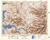
~ Hoquiam WA topo map, 1:250000 scale, 1 X 2 Degree, Historical, 1957, updated 1957
Hoquiam, Washington, USGS topographic map dated 1957.
Includes geographic coordinates (latitude and longitude). This topographic map is suitable for hiking, camping, and exploring, or framing it as a wall map.
Printed on-demand using high resolution imagery, on heavy weight and acid free paper, or alternatively on a variety of synthetic materials.
Topos available on paper, Waterproof, Poly, or Tyvek. Usually shipping rolled, unless combined with other folded maps in one order.
- Product Number: USGS-5411494
- Free digital map download (high-resolution, GeoPDF): Hoquiam, Washington (file size: 22 MB)
- Map Size: please refer to the dimensions of the GeoPDF map above
- Weight (paper map): ca. 55 grams
- Map Type: POD USGS Topographic Map
- Map Series: HTMC
- Map Verison: Historical
- Cell ID: 75031
- Scan ID: 239707
- Imprint Year: 1957
- Aerial Photo Year: 1945
- Datum: NAD27
- Map Projection: Transverse Mercator
- Map published by United States Army Corps of Engineers
- Map published by United States Army
- Map Language: English
- Scanner Resolution: 600 dpi
- Map Cell Name: Hoquiam
- Grid size: 1 X 2 Degree
- Date on map: 1957
- Map Scale: 1:250000
- Geographical region: Washington, United States
Neighboring Maps:
All neighboring USGS topo maps are available for sale online at a variety of scales.
Spatial coverage:
Topo map Hoquiam, Washington, covers the geographical area associated the following places:
- Clatskanie Heights - Timberland Village Mobile Home Park - Raymond - Rochester - Klaber - Wildwood - Alder - Marys Corner - Fayette - Blind Slough (historical) - Country Lane Mobile Home Park - Hilda - Vail - Chinook - Ostrander - Kopiah - Ryderwood - Country Estates Mobile Home Park - Eufaula Heights - Sandy Bend - Murnen - Middle Nemah - Klaus - Elk Creek - Carrolls - Littlerock - Alpha - Svensen Junction - Blakeslee Junction - Wabash - Belmore - Clatskanie - Salkum - Castle Rock - Cedarville - Lacamas - Bush - Goble - Five Corners - Bedford - Eufaula - Ethel - Montesano - Kid Valley - Carlson Landing - Crawfords Mobile Home Court - Ceres - Ohop Bob - Broadway Heights - Frankfort - Hammond - Winlock - South Union - South Montesano - Gearhart - Boistfort - Rhodesia Beach - East Hoquiam - Bay Center Junction - Beaver Homes - Mill Village Mobile Home Park - Onalaska - Columbia Valley Gardens - Bunker - Longview Heights - Western Junction - Riffe (historical) - Fishhawk (historical) - New Reliance - Linkshire Market Mobile Home Park - Brooklyn - Kyser (historical) - Melville - Mayger - Harmony Falls Landing (historical) - Frances - Delena - Doty - Pilgrim Heights - Headquarters - Rainier - Seahaven (historical) - Knappton - Forest - Balch - Dahlia - Helsing Junction - Ruth - Lindbergh - Eatonville - Davis - Grays River - Aberdeen Junction - Cougar - Pleasant Hill - Carlson - Olequa - Surprise Valley - Meskill - Central Park
- Map Area ID: AREA4746-124-122
- Northwest corner Lat/Long code: USGSNW47-124
- Northeast corner Lat/Long code: USGSNE47-122
- Southwest corner Lat/Long code: USGSSW46-124
- Southeast corner Lat/Long code: USGSSE46-122
- Northern map edge Latitude: 47
- Southern map edge Latitude: 46
- Western map edge Longitude: -124
- Eastern map edge Longitude: -122


