
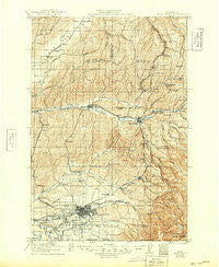
~ Walla Walla WA topo map, 1:125000 scale, 30 X 30 Minute, Historical, 1921, updated 1949
Walla Walla, Washington, USGS topographic map dated 1921.
Includes geographic coordinates (latitude and longitude). This topographic map is suitable for hiking, camping, and exploring, or framing it as a wall map.
Printed on-demand using high resolution imagery, on heavy weight and acid free paper, or alternatively on a variety of synthetic materials.
Topos available on paper, Waterproof, Poly, or Tyvek. Usually shipping rolled, unless combined with other folded maps in one order.
- Product Number: USGS-5411460
- Free digital map download (high-resolution, GeoPDF): Walla Walla, Washington (file size: 12 MB)
- Map Size: please refer to the dimensions of the GeoPDF map above
- Weight (paper map): ca. 55 grams
- Map Type: POD USGS Topographic Map
- Map Series: HTMC
- Map Verison: Historical
- Cell ID: 66877
- Scan ID: 244504
- Imprint Year: 1949
- Survey Year: 1919
- Datum: NAD
- Map Projection: Polyconic
- Map published by United States Geological Survey
- Map Language: English
- Scanner Resolution: 600 dpi
- Map Cell Name: Walla Walla
- Grid size: 30 X 30 Minute
- Date on map: 1921
- Map Scale: 1:125000
- Geographical region: Washington, United States
Neighboring Maps:
All neighboring USGS topo maps are available for sale online at a variety of scales.
Spatial coverage:
Topo map Walla Walla, Washington, covers the geographical area associated the following places:
- Robinson - Garrett - Sudbury - Tompkins - Valley Grove - College Place - Pickard - Waiilatpo (historical) - Stateline - Russell - Tracy - Bolles - Harsha - Mojonnier - Baker-Langdon - Paddock - Whitman - Prescott - Dumas - Ennis - Dixie Crossing - Eastman - Kooskooskie - Sapolil - Pedigo - Coppei - Alto - Dixie - Five Points - Menoken - McKay - Harbert - Relief - Hadley - Climax - Langdon - Calhounville - Walla Walla - Minnick - Berryman - Thiel - Long - Harvey - Buroker - Varna - Huntsville - Gilliam - Kibler - Waitsburg - Thomas - Clyde
- Map Area ID: AREA46.546-118.5-118
- Northwest corner Lat/Long code: USGSNW46.5-118.5
- Northeast corner Lat/Long code: USGSNE46.5-118
- Southwest corner Lat/Long code: USGSSW46-118.5
- Southeast corner Lat/Long code: USGSSE46-118
- Northern map edge Latitude: 46.5
- Southern map edge Latitude: 46
- Western map edge Longitude: -118.5
- Eastern map edge Longitude: -118


