
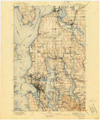
~ Snohomish WA topo map, 1:125000 scale, 30 X 30 Minute, Historical, 1897, updated 1940
Snohomish, Washington, USGS topographic map dated 1897.
Includes geographic coordinates (latitude and longitude). This topographic map is suitable for hiking, camping, and exploring, or framing it as a wall map.
Printed on-demand using high resolution imagery, on heavy weight and acid free paper, or alternatively on a variety of synthetic materials.
Topos available on paper, Waterproof, Poly, or Tyvek. Usually shipping rolled, unless combined with other folded maps in one order.
- Product Number: USGS-5411354
- Free digital map download (high-resolution, GeoPDF): Snohomish, Washington (file size: 10 MB)
- Map Size: please refer to the dimensions of the GeoPDF map above
- Weight (paper map): ca. 55 grams
- Map Type: POD USGS Topographic Map
- Map Series: HTMC
- Map Verison: Historical
- Cell ID: 66651
- Scan ID: 243816
- Imprint Year: 1940
- Survey Year: 1895
- Datum: Unstated
- Map Projection: Polyconic
- Map published by United States Geological Survey
- Map Language: English
- Scanner Resolution: 600 dpi
- Map Cell Name: Snohomish
- Grid size: 30 X 30 Minute
- Date on map: 1897
- Map Scale: 1:125000
- Geographical region: Washington, United States
Neighboring Maps:
All neighboring USGS topo maps are available for sale online at a variety of scales.
Spatial coverage:
Topo map Snohomish, Washington, covers the geographical area associated the following places:
- Avondale Mobile Home Park - Mercer Island Town - Arbor Heights - Pinehurst - Finn Hill - Lynnwood Mobile Park - Circle H Mobile Home Park - Stevens - Bryn Mawr Properties Mobile Home Park - Snohomish - Lynnwood - Glendale - Pontiac - Kenilworth - Interbay - Somerset - Seattle Hill - Alpine Mobile Home Park - Moorland - Delridge - East Seattle - Sunlight Beach - Riverside Mobile Estates - Magnolia Bluff - Lakeridge - Woodruff - Coalfield - Serene - Crossroads - Thrashers Corner - Canyon Recreational Vehicle Park - Meadowbrook - Sarvis Mobile Estates - Clyde Hill - Fobes Hill - Earlmont - Woodridge - Highlands - High Point - Loganberry Mobile Home Park - Twin Creek Mobile Home Park - Marks Mobile Home Park - Holly Park - Wallingford - Madrona - South Park - Tally Ho Mobile Home Park - Tamill - Firdale - Avondale - Rees Corner - Hollywood - Woodway - Victory Heights - Fortuna - Bryant - Beaumont - Midlakes - Cougar Hills - Ballard - Kennard Mobile Estates - Brighton - Robinswood - Shoreline - Yarrow Point - Fairway Estates Senior Mobile Home Park - University Village - Lago de Plata Villa Mobile Home Park - Kenmore - Bella Mobile Home Park - White Center - Moorlands - Sherwood Village Mobile Home Park - Newcastle - Echo Lake - Glendale - Hunts Point - Fremont - Machias - Sand Point - Kirkland - Newport Shores - Edgewater - Briarcliff - Spacette Mobile Home Community - North Park - Sammamish - Rose Hill - Capitol Hill - Factoria - Manor Heights Mobile Home Park - J and L Mobile Home Park - Shady Glen Mobile Home Park - Seattle Heights Mobile Home Park - Three Rivers Mobile Home Park - Woodinville - Phinney Ridge - Candlewood Estates Mobile Home Park - Belltown - Edmonds
- Map Area ID: AREA4847.5-122.5-122
- Northwest corner Lat/Long code: USGSNW48-122.5
- Northeast corner Lat/Long code: USGSNE48-122
- Southwest corner Lat/Long code: USGSSW47.5-122.5
- Southeast corner Lat/Long code: USGSSE47.5-122
- Northern map edge Latitude: 48
- Southern map edge Latitude: 47.5
- Western map edge Longitude: -122.5
- Eastern map edge Longitude: -122


