
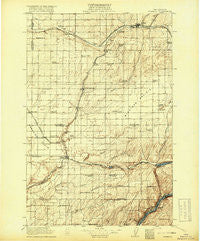
~ Connell WA topo map, 1:125000 scale, 30 X 30 Minute, Historical, 1918
Connell, Washington, USGS topographic map dated 1918.
Includes geographic coordinates (latitude and longitude). This topographic map is suitable for hiking, camping, and exploring, or framing it as a wall map.
Printed on-demand using high resolution imagery, on heavy weight and acid free paper, or alternatively on a variety of synthetic materials.
Topos available on paper, Waterproof, Poly, or Tyvek. Usually shipping rolled, unless combined with other folded maps in one order.
- Product Number: USGS-5411126
- Free digital map download (high-resolution, GeoPDF): Connell, Washington (file size: 8 MB)
- Map Size: please refer to the dimensions of the GeoPDF map above
- Weight (paper map): ca. 55 grams
- Map Type: POD USGS Topographic Map
- Map Series: HTMC
- Map Verison: Historical
- Cell ID: 65263
- Scan ID: 240640
- Survey Year: 1916
- Datum: Unstated
- Map Projection: Unstated
- Map published by United States Geological Survey
- Map Language: English
- Scanner Resolution: 600 dpi
- Map Cell Name: Connell
- Grid size: 30 X 30 Minute
- Date on map: 1918
- Map Scale: 1:125000
- Geographical region: Washington, United States
Neighboring Maps:
All neighboring USGS topo maps are available for sale online at a variety of scales.
Spatial coverage:
Topo map Connell, Washington, covers the geographical area associated the following places:
- Shano - Cactus - Schlomer - Windust - Cunningham - Kahlotus - Estes - Connell - Hatton - Five Corners - Farrington - Scott - Curry - Roxboro - Sulphur - Lind - Beatrice - Servia - Providence - Myers - Matthew
- Map Area ID: AREA4746.5-119-118.5
- Northwest corner Lat/Long code: USGSNW47-119
- Northeast corner Lat/Long code: USGSNE47-118.5
- Southwest corner Lat/Long code: USGSSW46.5-119
- Southeast corner Lat/Long code: USGSSE46.5-118.5
- Northern map edge Latitude: 47
- Southern map edge Latitude: 46.5
- Western map edge Longitude: -119
- Eastern map edge Longitude: -118.5


