
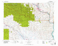
~ Wenatchee WA topo map, 1:100000 scale, 30 X 60 Minute, Historical, 1975, updated 1977
Wenatchee, Washington, USGS topographic map dated 1975.
Includes geographic coordinates (latitude and longitude). This topographic map is suitable for hiking, camping, and exploring, or framing it as a wall map.
Printed on-demand using high resolution imagery, on heavy weight and acid free paper, or alternatively on a variety of synthetic materials.
Topos available on paper, Waterproof, Poly, or Tyvek. Usually shipping rolled, unless combined with other folded maps in one order.
- Product Number: USGS-5411054
- Free digital map download (high-resolution, GeoPDF): Wenatchee, Washington (file size: 35 MB)
- Map Size: please refer to the dimensions of the GeoPDF map above
- Weight (paper map): ca. 55 grams
- Map Type: POD USGS Topographic Map
- Map Series: HTMC
- Map Verison: Historical
- Cell ID: 68568
- Scan ID: 244607
- Imprint Year: 1977
- Aerial Photo Year: 1973
- Datum: NAD27
- Map Projection: Universal Transverse Mercator
- Map published by United States Geological Survey
- Map Language: English
- Scanner Resolution: 600 dpi
- Map Cell Name: Wenatchee
- Grid size: 30 X 60 Minute
- Date on map: 1975
- Map Scale: 1:100000
- Geographical region: Washington, United States
Neighboring Maps:
All neighboring USGS topo maps are available for sale online at a variety of scales.
Spatial coverage:
Topo map Wenatchee, Washington, covers the geographical area associated the following places:
- Trinidad - East Wenatchee Bench - Foothills Senior Mobile Home Park - Cle Elum - Appleyard - West Wenatchee - Sunny Hill - Sunnyslope - Wenatchee - Patterson (historical) - Voltage - Horlick - Malaga - Monitor - Rock Island - Wenatchee Heights - Teanaway - Thorp - Liberty - South Cle Elum - Conifer Mobile Home Park - Twin Peaks Manor Mobile Home Park - Meadow Ridge Mobile Home Park - Scammon Landing - Olds - Roslyn - Blewett (historical) - Terrace Park - Saddleview Mobile Home Park - Dutch Settlement - Lauderdale Junction - Bristol - Ninth Street Trailer Park - Broadway - Heritage Haven Mobile Home Park - East Wenatchee
- Map Area ID: AREA47.547-121-120
- Northwest corner Lat/Long code: USGSNW47.5-121
- Northeast corner Lat/Long code: USGSNE47.5-120
- Southwest corner Lat/Long code: USGSSW47-121
- Southeast corner Lat/Long code: USGSSE47-120
- Northern map edge Latitude: 47.5
- Southern map edge Latitude: 47
- Western map edge Longitude: -121
- Eastern map edge Longitude: -120


