
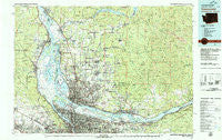
~ Vancouver WA topo map, 1:100000 scale, 30 X 60 Minute, Historical, 1979, updated 1980
Vancouver, Washington, USGS topographic map dated 1979.
Includes geographic coordinates (latitude and longitude). This topographic map is suitable for hiking, camping, and exploring, or framing it as a wall map.
Printed on-demand using high resolution imagery, on heavy weight and acid free paper, or alternatively on a variety of synthetic materials.
Topos available on paper, Waterproof, Poly, or Tyvek. Usually shipping rolled, unless combined with other folded maps in one order.
- Product Number: USGS-5411048
- Free digital map download (high-resolution, GeoPDF): Vancouver, Washington (file size: 36 MB)
- Map Size: please refer to the dimensions of the GeoPDF map above
- Weight (paper map): ca. 55 grams
- Map Type: POD USGS Topographic Map
- Map Series: HTMC
- Map Verison: Historical
- Cell ID: 68517
- Scan ID: 244455
- Imprint Year: 1980
- Woodland Tint: Yes
- Aerial Photo Year: 1975
- Edit Year: 1979
- Datum: NAD27
- Map Projection: Universal Transverse Mercator
- Map published by United States Geological Survey
- Map Language: English
- Scanner Resolution: 600 dpi
- Map Cell Name: Vancouver
- Grid size: 30 X 60 Minute
- Date on map: 1979
- Map Scale: 1:100000
- Geographical region: Washington, United States
Neighboring Maps:
All neighboring USGS topo maps are available for sale online at a variety of scales.
Spatial coverage:
Topo map Vancouver, Washington, covers the geographical area associated the following places:
- Portland - Whitwood Court - Holbrook - Prindle - Ellsworth - McLoughlin - Columbia Heights - Officers Row - Hazelwood - Minnehaha - Rye - Chapman - Evergreen - Hazel Dell - North Portland - Crawford - Knapp - Ariel - Spitzenberg - Folkenberg - Alameda - Riverview (historical) - Scappoose - Highland - Witch Hazel - Amboy - Ridgefield - Dayton - Saint Helens - Trenholm - Chapman Landing - Columbia City - Sylvan - Baker - Deer Island - Little Elkhorn - Orchards - Lucia - Cedarville - Bridal Veil - Hollywood - Molfait Tracts - Ireland - Bachelor Flat (historical) - Wood Village - Sara - Vancouver Junction - Alpine - Warrendale - Saint Johns - Barnes Heights - Saint John - Brush Prairie - Hayes - Caples - Cathlapotle (historical) - Marlene Village - Johnson Crossing - Yacolt - North Plains - Warren - Irvington - Plainview (historical) - Bethany - Montavilla - Cedar Mill - Cedar Hills - Powellhurst - Parkrose - Manor - Proebstel - Bonny Slope - Lake Shore - Venersborg - Dollar Corner - Dole - View - Etna - Piedmont - Yankton - Saint Cloud - Maywood Park - Walnut Grove - McNulty - Tanasbourne - Troutdale - Battle Ground - Skamania - Burlington - Mill Plain - West Pioneer - McLoughlin Heights - Heisson - Caples Landing - Canaan - Laurelhurst - Scotton Corner - Oak Park - Russell Landing - Washougal
- Map Area ID: AREA4645.5-123-122
- Northwest corner Lat/Long code: USGSNW46-123
- Northeast corner Lat/Long code: USGSNE46-122
- Southwest corner Lat/Long code: USGSSW45.5-123
- Southeast corner Lat/Long code: USGSSE45.5-122
- Northern map edge Latitude: 46
- Southern map edge Latitude: 45.5
- Western map edge Longitude: -123
- Eastern map edge Longitude: -122


