
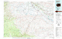
~ Toppenish WA topo map, 1:100000 scale, 30 X 60 Minute, Historical, 1979, updated 1997
Toppenish, Washington, USGS topographic map dated 1979.
Includes geographic coordinates (latitude and longitude). This topographic map is suitable for hiking, camping, and exploring, or framing it as a wall map.
Printed on-demand using high resolution imagery, on heavy weight and acid free paper, or alternatively on a variety of synthetic materials.
Topos available on paper, Waterproof, Poly, or Tyvek. Usually shipping rolled, unless combined with other folded maps in one order.
- Product Number: USGS-5411042
- Free digital map download (high-resolution, GeoPDF): Toppenish, Washington (file size: 27 MB)
- Map Size: please refer to the dimensions of the GeoPDF map above
- Weight (paper map): ca. 55 grams
- Map Type: POD USGS Topographic Map
- Map Series: HTMC
- Map Verison: Historical
- Cell ID: 68471
- Scan ID: 244319
- Imprint Year: 1997
- Woodland Tint: Yes
- Aerial Photo Year: 1975
- Edit Year: 1979
- Datum: NAD27
- Map Projection: Universal Transverse Mercator
- Map published by United States Geological Survey
- Map Language: English
- Scanner Resolution: 600 dpi
- Map Cell Name: Toppenish
- Grid size: 30 X 60 Minute
- Date on map: 1979
- Map Scale: 1:100000
- Geographical region: Washington, United States
Neighboring Maps:
All neighboring USGS topo maps are available for sale online at a variety of scales.
Spatial coverage:
Topo map Toppenish, Washington, covers the geographical area associated the following places:
- Venner - Bluelight - Rupple - Nass - Wesley Junction - Wapato - Midvale - Alfalfa - Flint - Satus - White Swan - Donald - Outlook - Granger - Liberty - Toppenish - Harrah - Ashue - Sawyer - Yethonat - Farron - Brownstown - Zillah - Sunnyside - Buena - Willy Dick Crossing - Emerald
- Map Area ID: AREA46.546-121-120
- Northwest corner Lat/Long code: USGSNW46.5-121
- Northeast corner Lat/Long code: USGSNE46.5-120
- Southwest corner Lat/Long code: USGSSW46-121
- Southeast corner Lat/Long code: USGSSE46-120
- Northern map edge Latitude: 46.5
- Southern map edge Latitude: 46
- Western map edge Longitude: -121
- Eastern map edge Longitude: -120


