
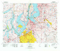
~ Tacoma WA topo map, 1:100000 scale, 30 X 60 Minute, Historical, 1975, updated 1977
Tacoma, Washington, USGS topographic map dated 1975.
Includes geographic coordinates (latitude and longitude). This topographic map is suitable for hiking, camping, and exploring, or framing it as a wall map.
Printed on-demand using high resolution imagery, on heavy weight and acid free paper, or alternatively on a variety of synthetic materials.
Topos available on paper, Waterproof, Poly, or Tyvek. Usually shipping rolled, unless combined with other folded maps in one order.
- Product Number: USGS-5411038
- Free digital map download (high-resolution, GeoPDF): Tacoma, Washington (file size: 30 MB)
- Map Size: please refer to the dimensions of the GeoPDF map above
- Weight (paper map): ca. 55 grams
- Map Type: POD USGS Topographic Map
- Map Series: HTMC
- Map Verison: Historical
- Cell ID: 68434
- Scan ID: 244188
- Imprint Year: 1977
- Aerial Photo Year: 1973
- Datum: NAD27
- Map Projection: Universal Transverse Mercator
- Map published by United States Geological Survey
- Map Language: English
- Scanner Resolution: 600 dpi
- Map Cell Name: Tacoma
- Grid size: 30 X 60 Minute
- Date on map: 1975
- Map Scale: 1:100000
- Geographical region: Washington, United States
Neighboring Maps:
All neighboring USGS topo maps are available for sale online at a variety of scales.
Spatial coverage:
Topo map Tacoma, Washington, covers the geographical area associated the following places:
- Atkinson - College Place Mobile Home Park - Shilo Mobile Home Park - Rio Verde Mobile Estates - Dorre Don - Seola Beach - Fragaria - Mountain Valley Mobile Home Park - North Puyallup - Empire View Mobile Home Park - Saint Clair - Sunset Terrace Mobile Home Park - Carlyon Beach - Evergreen Acres Mobile Home Park - Fairfax - Bethel - Skylark Village Mobile Home Park - Sunnydale - Oakland - Cascade Mobile Villa - Lakebay - White River Estate Mobile Home Park - Rhododendron Park - Alderton - Summer Villa Estates Mobile Home Park - Ponderosa Estates - Shady Hill Mobile Home Park - Lakeside Terrace Mobile Home Park - Waller - Bowman Hilton Mobile Home Park - Rosehilla - Glendale Mobile Home Park - Skyway Mobile Home Park - North West Mobile Home Park - Lakeland - Acorn Meadows Mobile Home Park - Longbranch - Town and Country Villa Mobile Home Park - Fern Heath - Manzanita - Maple Valley Heights - East Cromwell - Covington - Spanaway Mobile Village - Detroit (historical) - Rocky Ridge - Valleybrook Mobile Home Park - Dockton - Wildwood - Pacific - Sunbeach - Midway - Fife Heights - Graham Point - Sunrise Beach - Fairfield Mobile Home Park - Rignall - Evansville - Zenith - Buenna - Luana Beach - Wilkeson - Shafrans Mobile Estate - Mirror Lake - Tahoma - Newaukum - Sunrise Manor Mobile Home Park - Don Juan Mobile Home Park - Hillside - Double A Mobile Manor - Parkland - Graham - American Lake Garden Tract - Union Mill - Angle Lake Mobile Home Park - Raeco - Lake Desire - Berkeley - Benson Village Mobile Home Park - Orchard Grove - Southern Heights - Summerville Estates Mobile Home Park - Fircrest - Danville - Home - Chautauqua - Grant - Brookdale - Willo Vista Mobile Estates - Federal Way - Charwood Mobile Home Park - Elk Plain - South Bay - Tumwater - Pacific Gardens Mobile Home Park - Hillsdale - Golden Rose Mobile Home Park - Oaknoll Trailer Park - View Crest Mobile Home Park - Fair Harbor
- Map Area ID: AREA47.547-123-122
- Northwest corner Lat/Long code: USGSNW47.5-123
- Northeast corner Lat/Long code: USGSNE47.5-122
- Southwest corner Lat/Long code: USGSSW47-123
- Southeast corner Lat/Long code: USGSSE47-122
- Northern map edge Latitude: 47.5
- Southern map edge Latitude: 47
- Western map edge Longitude: -123
- Eastern map edge Longitude: -122


