
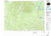
~ Shelton WA topo map, 1:100000 scale, 30 X 60 Minute, Historical, 1988, updated 1988
Shelton, Washington, USGS topographic map dated 1988.
Includes geographic coordinates (latitude and longitude). This topographic map is suitable for hiking, camping, and exploring, or framing it as a wall map.
Printed on-demand using high resolution imagery, on heavy weight and acid free paper, or alternatively on a variety of synthetic materials.
Topos available on paper, Waterproof, Poly, or Tyvek. Usually shipping rolled, unless combined with other folded maps in one order.
- Product Number: USGS-5411028
- Free digital map download (high-resolution, GeoPDF): Shelton, Washington (file size: 35 MB)
- Map Size: please refer to the dimensions of the GeoPDF map above
- Weight (paper map): ca. 55 grams
- Map Type: POD USGS Topographic Map
- Map Series: HTMC
- Map Verison: Historical
- Cell ID: 68357
- Scan ID: 243691
- Imprint Year: 1988
- Woodland Tint: Yes
- Aerial Photo Year: 1981
- Edit Year: 1988
- Datum: NAD27
- Map Projection: Universal Transverse Mercator
- Map published by United States Geological Survey
- Map Language: English
- Scanner Resolution: 600 dpi
- Map Cell Name: Shelton
- Grid size: 30 X 60 Minute
- Date on map: 1988
- Map Scale: 1:100000
- Geographical region: Washington, United States
Neighboring Maps:
All neighboring USGS topo maps are available for sale online at a variety of scales.
Spatial coverage:
Topo map Shelton, Washington, covers the geographical area associated the following places:
- Forest View Senior 55 Plus Community Mobile Home Park - McCleary - Grisdale - Frisken Wye - Carmill Station - Marmac - Pines Mobile Home Park - Bayshore - Oakland - Amanda Park - Union - Schneiders Prairie - Taylor Towne Manor Mobile Home Park - Elma - Nisson - Dayton - Shelton - Weatherwax - Axford - Rest - A - While Mobile Home Park - Mohrweis - Potlatch - Aberdeen Gardens - Evergreen Mobile Estates - Elizan Beach - Madrona Mobile Home Park - Neilton - New London - Hillgrove - Forbes - Wishkah - Riverside Mobile Home Park - Garden City - Hidden Haven Mobile Home Park - Quinault - Tahuya - Skokomish - Agate - New Kamilche - Oak Acres Mobile Home Park - Lilliwaup - Norwood - We and You Mobile Home Park - Sine - Minerva Beach Mobile Village Resort - Humptulips - Woodlawn - Kamilche - Dewatto - McCleary Junction - Rayville - Matlock - Viking West Mobile Home Park - Madrona Beach - Brockdale - Deckerville - Stimson - Hoodsport - Satsop
- Map Area ID: AREA47.547-124-123
- Northwest corner Lat/Long code: USGSNW47.5-124
- Northeast corner Lat/Long code: USGSNE47.5-123
- Southwest corner Lat/Long code: USGSSW47-124
- Southeast corner Lat/Long code: USGSSE47-123
- Northern map edge Latitude: 47.5
- Southern map edge Latitude: 47
- Western map edge Longitude: -124
- Eastern map edge Longitude: -123


