
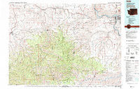
~ Clarkston WA topo map, 1:100000 scale, 30 X 60 Minute, Historical, 1981, updated 1981
Clarkston, Washington, USGS topographic map dated 1981.
Includes geographic coordinates (latitude and longitude). This topographic map is suitable for hiking, camping, and exploring, or framing it as a wall map.
Printed on-demand using high resolution imagery, on heavy weight and acid free paper, or alternatively on a variety of synthetic materials.
Topos available on paper, Waterproof, Poly, or Tyvek. Usually shipping rolled, unless combined with other folded maps in one order.
- Product Number: USGS-5410960
- Free digital map download (high-resolution, GeoPDF): Clarkston, Washington (file size: 34 MB)
- Map Size: please refer to the dimensions of the GeoPDF map above
- Weight (paper map): ca. 55 grams
- Map Type: POD USGS Topographic Map
- Map Series: HTMC
- Map Verison: Historical
- Cell ID: 67303
- Scan ID: 240546
- Imprint Year: 1981
- Woodland Tint: Yes
- Visual Version Number: 2
- Aerial Photo Year: 1977
- Edit Year: 1981
- Datum: NAD27
- Map Projection: Universal Transverse Mercator
- Map published by United States Geological Survey
- Map Language: English
- Scanner Resolution: 600 dpi
- Map Cell Name: Clarkston
- Grid size: 30 X 60 Minute
- Date on map: 1981
- Map Scale: 1:100000
- Geographical region: Washington, United States
Neighboring Maps:
All neighboring USGS topo maps are available for sale online at a variety of scales.
Spatial coverage:
Topo map Clarkston, Washington, covers the geographical area associated the following places:
- Unfried (historical) - Transfer - Pomeroy - Moses - Craige - Dayton - Whetstone - Mountain View - Silcott - Zumwalt - Tucannon - Cloverland - Pataha - Clarkston - Marengo - Jerry - Ronan - Grouse - Mountain Top - Vineland - Mentor - West Clarkston - Alpowa - Lewiston - North Lewiston - Turner - Stentz Spring - Mountain Home Park - Anatone - Patit - Rose Springs - Theon (historical) - Peola - Hanson Ferry - Covello - Clarkston Heights - Baileysburg - Highland - Asotin
- Map Area ID: AREA46.546-118-117
- Northwest corner Lat/Long code: USGSNW46.5-118
- Northeast corner Lat/Long code: USGSNE46.5-117
- Southwest corner Lat/Long code: USGSSW46-118
- Southeast corner Lat/Long code: USGSSE46-117
- Northern map edge Latitude: 46.5
- Southern map edge Latitude: 46
- Western map edge Longitude: -118
- Eastern map edge Longitude: -117


