
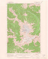
~ Glacier Peak WA topo map, 1:62500 scale, 15 X 15 Minute, Historical, 1950, updated 1965
Glacier Peak, Washington, USGS topographic map dated 1950.
Includes geographic coordinates (latitude and longitude). This topographic map is suitable for hiking, camping, and exploring, or framing it as a wall map.
Printed on-demand using high resolution imagery, on heavy weight and acid free paper, or alternatively on a variety of synthetic materials.
Topos available on paper, Waterproof, Poly, or Tyvek. Usually shipping rolled, unless combined with other folded maps in one order.
- Product Number: USGS-5409842
- Free digital map download (high-resolution, GeoPDF): Glacier Peak, Washington (file size: 9 MB)
- Map Size: please refer to the dimensions of the GeoPDF map above
- Weight (paper map): ca. 55 grams
- Map Type: POD USGS Topographic Map
- Map Series: HTMC
- Map Verison: Historical
- Cell ID: 54592
- Scan ID: 241304
- Imprint Year: 1965
- Woodland Tint: Yes
- Aerial Photo Year: 1950
- Field Check Year: 1950
- Datum: NAD27
- Map Projection: Polyconic
- Map published by United States Geological Survey
- Map Language: English
- Scanner Resolution: 600 dpi
- Map Cell Name: Glacier Peak
- Grid size: 15 X 15 Minute
- Date on map: 1950
- Map Scale: 1:62500
- Geographical region: Washington, United States
Neighboring Maps:
All neighboring USGS topo maps are available for sale online at a variety of scales.
Spatial coverage:
Topo map Glacier Peak, Washington, covers the geographical area associated the following places:
- Milk Creek - Camp Lake - Sulphur Mountain Lake - Miners Ridge - Baekos Creek - East Fork Milk Creek - Pumice Creek - Sitkum Creek - Fire Creek Pass - Sulphur Creek Campground - Chocolate Glacier - Grassy Point - Bath Lakes - Fourteenmile Creek - Thunder Basin - Kennedy Peak - Airplane Lake - Chikamin Creek - Kennedy Ridge Trail - Kennedy Hot Spring - Twin Lakes - Red Pass - Milk Lakes - White River Glacier - Tahlak Creek - Totem Pass - Box Mountain - Suiattle Trailhead - Dusty Creek - Lookout Lake - Glacier Ridge - Skullcap Peak - Kennedy Ridge - Cool Glacier - Suiattle Glacier - Diamond Lake - Hardtack Lake - Honeycomb Glacier - Triad Creek - Dolly Vista Shelter - Lake Byrne - Fire Creek Way (historical) - Gamma Peak - Kennedy Glacier - Camp Creek Ridge Trail (historical) - Vista Creek - Milk Lake Glacier - Black Mountain - Kid Pond - Grassy Point - Red Creek - Kennedy Hot Springs - Canyon Creek Shelter - Lyman Camp (historical) - Buckeye Basin - Rivord Lake - Fire Creek - Ermine Glacier - Sulphur Creek - Portal Peak - White Chuck Glacier - Kennedy Creek - Sitkum Glacier - Tenpeak Mountain - Miners Creek Shelter - Dusty Glacier - Scimitar Glacier - Skalabats Creek - Vista Ridge - Glacier Creek - Mount Saul - Reflection Pond - Lime Mountain - Lime Ridge - Mackinaw Shelter - White Chuck Cinder Cone - Chetwot Creek - South Guardian Rock - White Mountain - Chocolate Creek - Glacier Peak Wilderness - Fire Creek Trail (historical) - Small Creek - Sulphur Mountain - Bath Lake - North Guardian Rock - Miners Creek - Glacier Peak - Canyon Creek - Meadow Mountain Way (historical) - Gamma Ridge - Indian Head Peak - Image Lake - Gamma Hot Springs - Vista Glacier - Van Lake - Disappointment Peak - Fire Mountain - Box Mountain Lakes - Gamma Creek
- Map Area ID: AREA48.2548-121.25-121
- Northwest corner Lat/Long code: USGSNW48.25-121.25
- Northeast corner Lat/Long code: USGSNE48.25-121
- Southwest corner Lat/Long code: USGSSW48-121.25
- Southeast corner Lat/Long code: USGSSE48-121
- Northern map edge Latitude: 48.25
- Southern map edge Latitude: 48
- Western map edge Longitude: -121.25
- Eastern map edge Longitude: -121


