
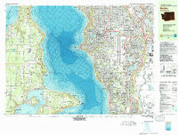
~ Burien WA topo map, 1:25000 scale, 7.5 X 15 Minute, Historical, 1983, updated 1983
Burien, Washington, USGS topographic map dated 1983.
Includes geographic coordinates (latitude and longitude). This topographic map is suitable for hiking, camping, and exploring, or framing it as a wall map.
Printed on-demand using high resolution imagery, on heavy weight and acid free paper, or alternatively on a variety of synthetic materials.
Topos available on paper, Waterproof, Poly, or Tyvek. Usually shipping rolled, unless combined with other folded maps in one order.
- Product Number: USGS-5409442
- Free digital map download (high-resolution, GeoPDF): Burien, Washington (file size: 40 MB)
- Map Size: please refer to the dimensions of the GeoPDF map above
- Weight (paper map): ca. 55 grams
- Map Type: POD USGS Topographic Map
- Map Series: HTMC
- Map Verison: Historical
- Cell ID: 75850
- Scan ID: 240275
- Imprint Year: 1983
- Woodland Tint: Yes
- Aerial Photo Year: 1977
- Edit Year: 1983
- Field Check Year: 1978
- Datum: NAD27
- Map Projection: Universal Transverse Mercator
- Map published by United States Geological Survey
- Map Language: English
- Scanner Resolution: 600 dpi
- Map Cell Name: Burien
- Grid size: 7.5 X 15 Minute
- Date on map: 1983
- Map Scale: 1:25000
- Geographical region: Washington, United States
Neighboring Maps:
All neighboring USGS topo maps are available for sale online at a variety of scales.
Spatial coverage:
Topo map Burien, Washington, covers the geographical area associated the following places:
- The Firs Mobile Home Park - Luana Beach - Inglesea - Midway - Des Moines - Klahanie - Puget View Mobile Home Park - Bow Lake Residential Mobile Home Community - Mar A Villa Mobile Home Park - Magnolia Beach - Bonel Mobile Manor - Mount View - Cowley - Zenith - Vashon - Mileta - Latona - Vue Mobile Home Park - Sunnydale - Sound Vista Mobile Home Park - Fern Heath - Vermontville (historical) - Dilworth - Portage - Chautauqua - Southern Heights - Normandy Park - Five Corners - Pine Terrace Mobile Home Park - McVan - Shorewood - Midway Mobile Mansions - Seahurst - Tukwila - Colvos - Cedarhurst - Angle Lake Mobile Home Park - Tyee Valley Mobile Manor - Beverly Park - Shawnee - Empire View Mobile Home Park - Riverton Heights - Riverton - Skyway - Burton - Seola Beach - Highline - Evansville - Des Moines Estates Mobile Home Park - North Hill - Foster - Boulevard Park - Gregory Heights - Maury - Circle K Mobile Home Park - Shafrans Mobile Estate - Skyway Mobile Home Park - Ellisport - Burien - Raeco - Southgate Mobile Home Park - Town and Country Villa Mobile Home Park - Orchard Trailer Park - McMicken Heights - SeaTac - Glen Acres - Bethel Park - Allentown
- Map Area ID: AREA47.547.375-122.5-122.25
- Northwest corner Lat/Long code: USGSNW47.5-122.5
- Northeast corner Lat/Long code: USGSNE47.5-122.25
- Southwest corner Lat/Long code: USGSSW47.375-122.5
- Southeast corner Lat/Long code: USGSSE47.375-122.25
- Northern map edge Latitude: 47.5
- Southern map edge Latitude: 47.375
- Western map edge Longitude: -122.5
- Eastern map edge Longitude: -122.25


