
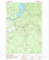
~ Yale Dam WA topo map, 1:24000 scale, 7.5 X 7.5 Minute, Historical, 1986, updated 1994
Yale Dam, Washington, USGS topographic map dated 1986.
Includes geographic coordinates (latitude and longitude). This topographic map is suitable for hiking, camping, and exploring, or framing it as a wall map.
Printed on-demand using high resolution imagery, on heavy weight and acid free paper, or alternatively on a variety of synthetic materials.
Topos available on paper, Waterproof, Poly, or Tyvek. Usually shipping rolled, unless combined with other folded maps in one order.
- Product Number: USGS-5409418
- Free digital map download (high-resolution, GeoPDF): Yale Dam, Washington (file size: 14 MB)
- Map Size: please refer to the dimensions of the GeoPDF map above
- Weight (paper map): ca. 55 grams
- Map Type: POD USGS Topographic Map
- Map Series: HTMC
- Map Verison: Historical
- Cell ID: 50023
- Scan ID: 244829
- Imprint Year: 1994
- Woodland Tint: Yes
- Photo Inspection Year: 1990
- Aerial Photo Year: 1982
- Edit Year: 1993
- Field Check Year: 1984
- Datum: NAD27
- Map Projection: Lambert Conformal Conic
- Provisional map: Yes
- Map published by United States Geological Survey
- Map Language: English
- Scanner Resolution: 600 dpi
- Map Cell Name: Yale Dam
- Grid size: 7.5 X 7.5 Minute
- Date on map: 1986
- Map Scale: 1:24000
- Geographical region: Washington, United States
Neighboring Maps:
All neighboring USGS topo maps are available for sale online at a variety of scales.
Spatial coverage:
Topo map Yale Dam, Washington, covers the geographical area associated the following places:
- North Siouxon Creek - Lost Lake - Speelyai Hill Viewpoint - Fly Creek - Green Knob - Yale Dam - Canyon Creek - North Country Emergency Medical Services Cresap Bay Station - Saddle Dam - Little Fly Creek - Chelatchie Prarie Mill Pond Dam - Yacolt Division - Chelatchie Prarie Mill Pond - Saddle Dam Campground - Cowlitz - Skamania Fire District 7 Station 74 - Siouxon Creek - Tumtum Mountain
- Map Area ID: AREA4645.875-122.375-122.25
- Northwest corner Lat/Long code: USGSNW46-122.375
- Northeast corner Lat/Long code: USGSNE46-122.25
- Southwest corner Lat/Long code: USGSSW45.875-122.375
- Southeast corner Lat/Long code: USGSSE45.875-122.25
- Northern map edge Latitude: 46
- Southern map edge Latitude: 45.875
- Western map edge Longitude: -122.375
- Eastern map edge Longitude: -122.25


