
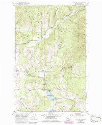
~ White Mud Lake WA topo map, 1:24000 scale, 7.5 X 7.5 Minute, Historical, 1952, updated 1986
White Mud Lake, Washington, USGS topographic map dated 1952.
Includes geographic coordinates (latitude and longitude). This topographic map is suitable for hiking, camping, and exploring, or framing it as a wall map.
Printed on-demand using high resolution imagery, on heavy weight and acid free paper, or alternatively on a variety of synthetic materials.
Topos available on paper, Waterproof, Poly, or Tyvek. Usually shipping rolled, unless combined with other folded maps in one order.
- Product Number: USGS-5409208
- Free digital map download (high-resolution, GeoPDF): White Mud Lake, Washington (file size: 13 MB)
- Map Size: please refer to the dimensions of the GeoPDF map above
- Weight (paper map): ca. 55 grams
- Map Type: POD USGS Topographic Map
- Map Series: HTMC
- Map Verison: Historical
- Cell ID: 48714
- Scan ID: 244650
- Imprint Year: 1986
- Woodland Tint: Yes
- Photo Revision Year: 1986
- Aerial Photo Year: 1983
- Edit Year: 1986
- Field Check Year: 1952
- Datum: NAD27
- Map Projection: Polyconic
- Map published by United States Geological Survey
- Map Language: English
- Scanner Resolution: 600 dpi
- Map Cell Name: White Mud Lake
- Grid size: 7.5 X 7.5 Minute
- Date on map: 1952
- Map Scale: 1:24000
- Geographical region: Washington, United States
Neighboring Maps:
All neighboring USGS topo maps are available for sale online at a variety of scales.
Spatial coverage:
Topo map White Mud Lake, Washington, covers the geographical area associated the following places:
- Finley Gulch - Rosanna Lake Dam - South Fork Mill Creek - Fort Colville Grange - White Lake - Douglass Lake - Middle Fork Mill Creek - Old Dominion Mine - Coonrad Hill - Jones Ridge - Three Forks - Graham Hill - White Lake School - De Hart Lake - Colville Division - Grevit Creek - Prouty Corners - Smith Airport - Peery Lake - Graham School - Hawkins Quarry - The Knob - Jack Hook Gulch - Blue Bird Canyon - Thompson Lake - Joes Ridge - Old Town Mountain - Crusher Canyon - White Lake Grange - Tulare Dolomite Quarry - Saint John's Episcopal Church - Mill Creek School - Dry Gulch - Tepee Springs - Hull Creek - White Mud Lake - Keogh Lake - North Fork Mill Creek - Prouty Creek - White Rock Canyon - Colville Gun Club - Truman Wood Creek - Aladdin Pit
- Map Area ID: AREA48.62548.5-117.875-117.75
- Northwest corner Lat/Long code: USGSNW48.625-117.875
- Northeast corner Lat/Long code: USGSNE48.625-117.75
- Southwest corner Lat/Long code: USGSSW48.5-117.875
- Southeast corner Lat/Long code: USGSSE48.5-117.75
- Northern map edge Latitude: 48.625
- Southern map edge Latitude: 48.5
- Western map edge Longitude: -117.875
- Eastern map edge Longitude: -117.75


