
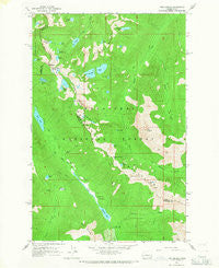
~ The Cradle WA topo map, 1:24000 scale, 7.5 X 7.5 Minute, Historical, 1965, updated 1967
The Cradle, Washington, USGS topographic map dated 1965.
Includes geographic coordinates (latitude and longitude). This topographic map is suitable for hiking, camping, and exploring, or framing it as a wall map.
Printed on-demand using high resolution imagery, on heavy weight and acid free paper, or alternatively on a variety of synthetic materials.
Topos available on paper, Waterproof, Poly, or Tyvek. Usually shipping rolled, unless combined with other folded maps in one order.
- Product Number: USGS-5408652
- Free digital map download (high-resolution, GeoPDF): The Cradle, Washington (file size: 14 MB)
- Map Size: please refer to the dimensions of the GeoPDF map above
- Weight (paper map): ca. 55 grams
- Map Type: POD USGS Topographic Map
- Map Series: HTMC
- Map Verison: Historical
- Cell ID: 44704
- Scan ID: 244248
- Imprint Year: 1967
- Woodland Tint: Yes
- Aerial Photo Year: 1958
- Field Check Year: 1965
- Datum: NAD27
- Map Projection: Polyconic
- Map published by United States Geological Survey
- Map Language: English
- Scanner Resolution: 600 dpi
- Map Cell Name: The Cradle
- Grid size: 7.5 X 7.5 Minute
- Date on map: 1965
- Map Scale: 1:24000
- Geographical region: Washington, United States
Neighboring Maps:
All neighboring USGS topo maps are available for sale online at a variety of scales.
Spatial coverage:
Topo map The Cradle, Washington, covers the geographical area associated the following places:
- Skeeter Creek - Welcome Lake - Squitch Lake - Carrie Lake - Sprite Lake - Trico Mountain - Cle Elum Ranger District - Scatter Creek - M M Lake - Lower Phoebe Lake - Talus Lake - Trico Lake - Lake Phoebe - Granite Mountain - Paddy-Go-Easy Pass - Robin Lakes - Tucquala Meadow Trailhead - Tucquala Meadow Campground - Klonaqua Lakes - Turquoise Lake - Fish Lake Campground - Granite Mountain Potholes - Snowall Creek - Tuck Lake - Tucquala Lake - Scatter Creek Campground - Squaw Lake - Klonaqua Lake Dam - French Potholes - Fish Lake Guard Station - Shoal Lake - Jungfrau Lake - Bobs Lake - The Cradle - Tucks Pot - Hyas Lake - Lake Leland - Todd Lake
- Map Area ID: AREA47.62547.5-121.125-121
- Northwest corner Lat/Long code: USGSNW47.625-121.125
- Northeast corner Lat/Long code: USGSNE47.625-121
- Southwest corner Lat/Long code: USGSSW47.5-121.125
- Southeast corner Lat/Long code: USGSSE47.5-121
- Northern map edge Latitude: 47.625
- Southern map edge Latitude: 47.5
- Western map edge Longitude: -121.125
- Eastern map edge Longitude: -121


