
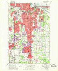
~ Tacoma South WA topo map, 1:24000 scale, 7.5 X 7.5 Minute, Historical, 1961, updated 1970
Tacoma South, Washington, USGS topographic map dated 1961.
Includes geographic coordinates (latitude and longitude). This topographic map is suitable for hiking, camping, and exploring, or framing it as a wall map.
Printed on-demand using high resolution imagery, on heavy weight and acid free paper, or alternatively on a variety of synthetic materials.
Topos available on paper, Waterproof, Poly, or Tyvek. Usually shipping rolled, unless combined with other folded maps in one order.
- Product Number: USGS-5408572
- Free digital map download (high-resolution, GeoPDF): Tacoma South, Washington (file size: 16 MB)
- Map Size: please refer to the dimensions of the GeoPDF map above
- Weight (paper map): ca. 55 grams
- Map Type: POD USGS Topographic Map
- Map Series: HTMC
- Map Verison: Historical
- Cell ID: 71784
- Scan ID: 244169
- Imprint Year: 1970
- Woodland Tint: Yes
- Photo Revision Year: 1968
- Aerial Photo Year: 1968
- Field Check Year: 1961
- Datum: NAD27
- Map Projection: Polyconic
- Map published by United States Geological Survey
- Map Language: English
- Scanner Resolution: 600 dpi
- Map Cell Name: Tacoma South
- Grid size: 7.5 X 7.5 Minute
- Date on map: 1961
- Map Scale: 1:24000
- Geographical region: Washington, United States
Neighboring Maps:
All neighboring USGS topo maps are available for sale online at a variety of scales.
Spatial coverage:
Topo map Tacoma South, Washington, covers the geographical area associated the following places:
- Diru Mobile Home Park - Fairfield Mobile Home Park - Rancho Villa Mobile Home Park - Oaknoll Trailer Park - Sunnyside Mobile Home Park - Canterbury Estates Mobile Home Park - Evergreen Manor Mobile Home Park - Excelsior - Miller's Villa Mobile Home Park - Salishan - Mount Tacoma Mobile Park - Golden Given Mobile Home Park - Franklin Pierce Mobile Estates - North West Mobile Home Park - Karwin Village Mobile Home Park - Wilkeson Gardens Mobile Home Park - Parkland Mobile Village - Midland Meadows Mobile Home Park - Tacoma Junction - Hillsdale - Pacific Gardens Mobile Home Park - Carriage Mobile Home Court - Lakeview - Pinecrest Mobile Home Park - Harvard View Mobile Home Park - Parkland - Weller Martin Mobile Home Park - Tacoma Country Estates Mobile Home Park - Manitou - Tyee Mobile Park - South Tacoma - Allison - Valleybrook Mobile Home Park - Fairfield Estates Mobile Home Park - Brookwood Mobile Home Park - Midland - Clover Creek Trailer Court - Fern Hill - Brookdale - One Hundred Thirty - Eighth Park Mobile Estates - Charleton Lake Estates Mobile Home Park - Twin Oaks Mobile Home Park - Fairlane Terrace Mobile Home Park - Monta Vista - Ohana Estates Mobile Home Park - Manor Mobile Home Park - Firwood Mobile Home Park - Larchmont - Mobile Manor - Oakland - Francis Mobile Home Court - Brookdale Greens Mobile Home Park - The Maples Mobile Home Park
- Map Area ID: AREA47.2547.125-122.5-122.375
- Northwest corner Lat/Long code: USGSNW47.25-122.5
- Northeast corner Lat/Long code: USGSNE47.25-122.375
- Southwest corner Lat/Long code: USGSSW47.125-122.5
- Southeast corner Lat/Long code: USGSSE47.125-122.375
- Northern map edge Latitude: 47.25
- Southern map edge Latitude: 47.125
- Western map edge Longitude: -122.5
- Eastern map edge Longitude: -122.375


