
~ Spirit Lake East WA topo map, 1:24000 scale, 7.5 X 7.5 Minute, Historical, 1984, updated 1984
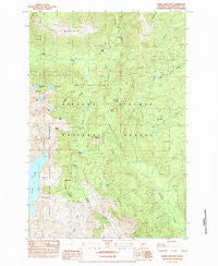
Spirit Lake East, Washington, USGS topographic map dated 1984.
Includes geographic coordinates (latitude and longitude). This topographic map is suitable for hiking, camping, and exploring, or framing it as a wall map.
Printed on-demand using high resolution imagery, on heavy weight and acid free paper, or alternatively on a variety of synthetic materials.
Topos available on paper, Waterproof, Poly, or Tyvek. Usually shipping rolled, unless combined with other folded maps in one order.
- Product Number: USGS-5408208
- Free digital map download (high-resolution, GeoPDF): Spirit Lake East, Washington (file size: 16 MB)
- Map Size: please refer to the dimensions of the GeoPDF map above
- Weight (paper map): ca. 55 grams
- Map Type: POD USGS Topographic Map
- Map Series: HTMC
- Map Verison: Historical
- Cell ID: 42510
- Scan ID: 243899
- Imprint Year: 1984
- Woodland Tint: Yes
- Aerial Photo Year: 1980
- Edit Year: 1984
- Field Check Year: 1981
- Datum: NAD27
- Map Projection: Lambert Conformal Conic
- Provisional map: Yes
- Map published by United States Geological Survey
- Map Language: English
- Scanner Resolution: 600 dpi
- Map Cell Name: Spirit Lake East
- Grid size: 7.5 X 7.5 Minute
- Date on map: 1984
- Map Scale: 1:24000
- Geographical region: Washington, United States
Neighboring Maps:
All neighboring USGS topo maps are available for sale online at a variety of scales.
Spatial coverage:
Topo map Spirit Lake East, Washington, covers the geographical area associated the following places:
- Panhandle Lake - Curtis Lake - Ryan Lake - Donnybrook Forest Camp (historical) - Bear Meadow Viewpoint - Independence Pass - Bismark Mountain - Bear Pass - Cedar Creek Viewpoint - Ghost Lake - Golconda Mine - Boot Lake - Harmony Falls Lodge (historical) - Grizzly Creek - Ryan Lake Picnic Area and Viewpoint - Harmony Viewpoint - Saint Charles Lake - Independence Pass Viewpoint - Obscurity Lake - Independence Pass Interpretive Trail - Goat Mountain - Chicago Mine - Strawberry Lookout - Ryan Lake Interpretive Site - Norway Pass Trailhead - Sweden Mine (historical) - Cedar Creek Pass - Polar Star Mine - Cedar Creek Forest Camp (historical) - Harmony Falls - Grizzly Lake - Mount Saint Helens Viewpoint - Fringe Viewpoint - Commonwealth Mine - Strawberry Lake - Meta Lake Interpretive Site - Norway Pass - Last Hope Mine - Bear Meadow - Smith Creek Viewpoint - Donnybrook Viewpoint - Miners Car Interpretive Site - Meta Lake
- Map Area ID: AREA46.37546.25-122.125-122
- Northwest corner Lat/Long code: USGSNW46.375-122.125
- Northeast corner Lat/Long code: USGSNE46.375-122
- Southwest corner Lat/Long code: USGSSW46.25-122.125
- Southeast corner Lat/Long code: USGSSE46.25-122
- Northern map edge Latitude: 46.375
- Southern map edge Latitude: 46.25
- Western map edge Longitude: -122.125
- Eastern map edge Longitude: -122


