
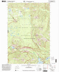
~ Spiral Butte WA topo map, 1:24000 scale, 7.5 X 7.5 Minute, Historical, 2000, updated 2003
Spiral Butte, Washington, USGS topographic map dated 2000.
Includes geographic coordinates (latitude and longitude). This topographic map is suitable for hiking, camping, and exploring, or framing it as a wall map.
Printed on-demand using high resolution imagery, on heavy weight and acid free paper, or alternatively on a variety of synthetic materials.
Topos available on paper, Waterproof, Poly, or Tyvek. Usually shipping rolled, unless combined with other folded maps in one order.
- Product Number: USGS-5408206
- Free digital map download (high-resolution, GeoPDF): Spiral Butte, Washington (file size: 17 MB)
- Map Size: please refer to the dimensions of the GeoPDF map above
- Weight (paper map): ca. 55 grams
- Map Type: POD USGS Topographic Map
- Map Series: HTMC
- Map Verison: Historical
- Cell ID: 42504
- Scan ID: 243898
- Imprint Year: 2003
- Woodland Tint: Yes
- Aerial Photo Year: 1996
- Edit Year: 2000
- Datum: NAD27
- Map Projection: Lambert Conformal Conic
- Map published by United States Forest Service
- Map Language: English
- Scanner Resolution: 600 dpi
- Map Cell Name: Spiral Butte
- Grid size: 7.5 X 7.5 Minute
- Date on map: 2000
- Map Scale: 1:24000
- Geographical region: Washington, United States
Neighboring Maps:
All neighboring USGS topo maps are available for sale online at a variety of scales.
Spatial coverage:
Topo map Spiral Butte, Washington, covers the geographical area associated the following places:
- Clear Creek Falls - Apple Lake - Muddy Creek - North Fork Clear Creek - Hill Lake - Blankenship Meadows - McAllister Trail - Mosquito Valley - Sand Ridge Trail - Blankenship Meadows Trail - Summit Lakes - Little Wildcat Trail - Dog Lake - North Fork Tieton River - Clear Lake South Campground - Twin Sisters Trail - Sand Ridge - Clear Lake North Campground - Bootjack Rock - Camp Dudley - State University Survey Camp - Clear Lake Campground - Indian Creek Trailhead - Shellrock Lake Trail - Cramer Lake Trail - Blakenship Lakes - Indian Creek Meadows - Ironstone Mountain - Indian Spring - Cold Creek - McNeil Peak - Clear Lake - Tumac Mountain - Arnesons Peak - Twin Peaks - Fox Meadow - Pear Lake - Dog Lake - Sand Ridge Trailhead - Otter Lake - Art Lake - Big Peak Trail - State College of Washington Survey Camp - Pillar Lake - Pear Butte - Clear Creek - Hogback Trail - Round Mountain - Spiral Butte - Shellrock Lake - McNeil Creek - Dancing Lady Lake - Cramer Lake - Rattlesnake Trail - Clear Creek Overlook - South Fork Clear Creek - Clear Creek Dam - Round Lake - Indian Creek Corrals - Ironstone Mountain Trail - Long John Lake - Clear Lake Picnic Area and Boat Landing - Kamiakan Butte - Indian Creek Trail
- Map Area ID: AREA46.7546.625-121.375-121.25
- Northwest corner Lat/Long code: USGSNW46.75-121.375
- Northeast corner Lat/Long code: USGSNE46.75-121.25
- Southwest corner Lat/Long code: USGSSW46.625-121.375
- Southeast corner Lat/Long code: USGSSE46.625-121.25
- Northern map edge Latitude: 46.75
- Southern map edge Latitude: 46.625
- Western map edge Longitude: -121.375
- Eastern map edge Longitude: -121.25


