
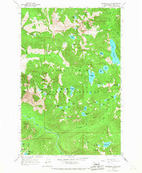
~ Snoqualmie Lake WA topo map, 1:24000 scale, 7.5 X 7.5 Minute, Historical, 1965, updated 1967
Snoqualmie Lake, Washington, USGS topographic map dated 1965.
Includes geographic coordinates (latitude and longitude). This topographic map is suitable for hiking, camping, and exploring, or framing it as a wall map.
Printed on-demand using high resolution imagery, on heavy weight and acid free paper, or alternatively on a variety of synthetic materials.
Topos available on paper, Waterproof, Poly, or Tyvek. Usually shipping rolled, unless combined with other folded maps in one order.
- Product Number: USGS-5408112
- Free digital map download (high-resolution, GeoPDF): Snoqualmie Lake, Washington (file size: 17 MB)
- Map Size: please refer to the dimensions of the GeoPDF map above
- Weight (paper map): ca. 55 grams
- Map Type: POD USGS Topographic Map
- Map Series: HTMC
- Map Verison: Historical
- Cell ID: 41892
- Scan ID: 243824
- Imprint Year: 1967
- Woodland Tint: Yes
- Aerial Photo Year: 1958
- Field Check Year: 1965
- Datum: NAD27
- Map Projection: Polyconic
- Map published by United States Geological Survey
- Map Language: English
- Scanner Resolution: 600 dpi
- Map Cell Name: Snoqualmie Lake
- Grid size: 7.5 X 7.5 Minute
- Date on map: 1965
- Map Scale: 1:24000
- Geographical region: Washington, United States
Neighboring Maps:
All neighboring USGS topo maps are available for sale online at a variety of scales.
Spatial coverage:
Topo map Snoqualmie Lake, Washington, covers the geographical area associated the following places:
- Judy Lake - Horseshoe Lake - Price Lake - Hi-Low Lake - Snoqualmie Lake Potholes - Dream Lake - Gouging Lake - Cascade Mountain - Treen Peak - Rock Lake - Smith Creek - Mount Price - Lower Garfield Mountain Lake - Green Ridge Lake - Camp Robber Valley - Smith Lake - Upper Garfield Mountain Lake - Elbow Lake - Goat Creek - Little Myrtle Lake - Pothole Lake - Goat Lake - Anderson Lake - Marten Creek - Lake Pugsley - Big Creek - Little Hester Lake - Dingford Creek Falls - Quartz Lake - Dingford Creek - Camp Robber Creek - Nordrum Lake - Bear Lake - Carole Lake - Deer Lake - Otter Falls - Myrtle Lake - Little Derrick Lake - Nimue Lake - Lake Dorothy - Hester Lake - Snoqualmie Lake - Pumpkinseed Lake - Charlie Brown Lake - Lunker Lake - Merlin Lake - Cripple Creek - Wildcat Creek - Florence Falls - Lipsy Lake - Le Fay Lake - Garfield Mountain
- Map Area ID: AREA47.62547.5-121.5-121.375
- Northwest corner Lat/Long code: USGSNW47.625-121.5
- Northeast corner Lat/Long code: USGSNE47.625-121.375
- Southwest corner Lat/Long code: USGSSW47.5-121.5
- Southeast corner Lat/Long code: USGSSE47.5-121.375
- Northern map edge Latitude: 47.625
- Southern map edge Latitude: 47.5
- Western map edge Longitude: -121.5
- Eastern map edge Longitude: -121.375


