
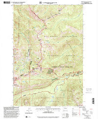
~ Norse Peak WA topo map, 1:24000 scale, 7.5 X 7.5 Minute, Historical, 2000, updated 2001
Norse Peak, Washington, USGS topographic map dated 2000.
Includes geographic coordinates (latitude and longitude). This topographic map is suitable for hiking, camping, and exploring, or framing it as a wall map.
Printed on-demand using high resolution imagery, on heavy weight and acid free paper, or alternatively on a variety of synthetic materials.
Topos available on paper, Waterproof, Poly, or Tyvek. Usually shipping rolled, unless combined with other folded maps in one order.
- Product Number: USGS-5406932
- Free digital map download (high-resolution, GeoPDF): Norse Peak, Washington (file size: 19 MB)
- Map Size: please refer to the dimensions of the GeoPDF map above
- Weight (paper map): ca. 55 grams
- Map Type: POD USGS Topographic Map
- Map Series: HTMC
- Map Verison: Historical
- Cell ID: 72479
- Scan ID: 242851
- Imprint Year: 2001
- Woodland Tint: Yes
- Aerial Photo Year: 1997
- Edit Year: 2000
- Datum: NAD27
- Map Projection: Lambert Conformal Conic
- Map published by United States Geological Survey
- Map published by United States Forest Service
- Map Language: English
- Scanner Resolution: 600 dpi
- Map Cell Name: Norse Peak
- Grid size: 7.5 X 7.5 Minute
- Date on map: 2000
- Map Scale: 1:24000
- Geographical region: Washington, United States
Neighboring Maps:
All neighboring USGS topo maps are available for sale online at a variety of scales.
Spatial coverage:
Topo map Norse Peak, Washington, covers the geographical area associated the following places:
- Bullion Basin - Sand Flats - Pickhandle Gap - Morse Creek Campground - Scout Pass - Elizabeth Lake - Basin Lake - Fidelity - Cement Basin - Timber Creek - Crystal Mountain Ski Resort - Miners Lakes - Elizabeth Creek - Gold Hill - Crown Point - Hen Skin Lake - Mesatchee Creek - Barnard Saddle - Castle Mountain Trail - Martinson Gap - Blue Bell Pass - Pierce County Fire District 25 Crystal Mountain Station - Placer Lake Dam - Rainier Fork American River - Union Creek Trail - Little Crow Basin - Bear Gap - Hayden Pass - Norse Peak - Big Crow Basin - Placer Lake - Lake Basin - Crystal Mountain Area - Cement Creek - Reese Lake - Pickhandle Basin - Lodgepole Campground - Castle Mountain - Goat Lake - Morse Creek - North Fork Union Creek - Pickhandle Point
- Map Area ID: AREA4746.875-121.5-121.375
- Northwest corner Lat/Long code: USGSNW47-121.5
- Northeast corner Lat/Long code: USGSNE47-121.375
- Southwest corner Lat/Long code: USGSSW46.875-121.5
- Southeast corner Lat/Long code: USGSSE46.875-121.375
- Northern map edge Latitude: 47
- Southern map edge Latitude: 46.875
- Western map edge Longitude: -121.5
- Eastern map edge Longitude: -121.375


